|
|
|
|
| Missing In Action (MIA) | Prisoners Of War (POW) | Unexploded Ordnance (UXO) |
| Chronology | Locations | Aircraft | Ships | Submit Info | How You Can Help | Donate |
|
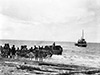  U.S. Army c1943 |
Location Lat 8° 43' 0S Long 148° 26' 60E Hariko is located on the north coast of New Guinea. Also spelled Harigo. Borders Hariko Bay to the east and Boreo to the north and beyond New Strip and Duropa Plantation at Cape Endiadere. To the south is Cape Sudest with foot tracks leading inland. Prewar and during the Pacific War part of the Northern District of the Territory of Papua. Today located in Ijivitari District of Oro Province in Papua New Guinea (PNG). Wartime History By early November 1942, the U.S. Army Quartermaster Colonel Laurence A. McKenny planned to establish an advanced supply dump at Hariko to support operations against Cape Endiadere with Hariko Bay used as an anchorage for small ships. On November 16, 1942 a small boat with Brigadier General Hanford MacNider arrives at Hariko and established his headquarters for "Warren Force". Later that afternoon, three small ships: Minnamurra with General Harding embarked, Bonwin, Alacrity and a captured Japanese barge with Brigadier General Albert W. Waldron embarked transporting two 25 pounders guns plus supplies and ammunition. In the afternoon when the four vessel reached Hariko then targeted by a Japanese air raid by Zeros and Val dive bombers from 582 Kokutai that strafed and bombed and while the soldiers aboard returned fire with only their small arms until the ships caught fire and those aboard were forced to swim ashore. In total, 24 were killed including Lieutenant Colonel Laurence McKenny (MIA) and Private George Green (MIA) plus most of the supplies and ammunition were lost. On November 21, 1942 a Japanese air raid by dive bombers sinks a barge off Hariko. During December 1942 eight M3 Stuart tanks were shipped to Milne Bay then transported by barge to Oro Bay then towed to Hariko. Overnight, the tanks were driven up the north coast with one track in the sea to their jump off position for use in the Buna-Sanananda area. By early 1943, Hariko was developed into a base area and the U.S. Army built a road that connected Hariko northward to Cape Endiadere and southward to Cape Sudest. References U.S. Army in World War II Victory in Papua: Chapter VII The Advance on the Beachhead page 124, footnote 19 Hell's Battlefield (2012) by Phil Bradley pages 134 (December 1942 tanks land), 135 (map) Red Arrow Across the Pacific (2024) pages 173 (map), 177-179, 192-194, 169-172, 176, 179, 183, 189, 195, 202, 214, 218, 169-184, 238-240, 262-263, 272, 486 (index Hariko) FindAGrave - LtCol Laurence Alderman McKenny (obituary) FindAGrave - Pvt George Green (tablets of the missing photo) Contribute
Information Last Updated
|
Map January 1943 Map Fallingrain |
| Discussion Forum | Daily Updates | Reviews | Museums | Interviews & Oral Histories |
|