|
|
|
|
| Missing In Action (MIA) | Prisoners Of War (POW) | Unexploded Ordnance (UXO) |
| Chronology | Locations | Aircraft | Ships | Submit Info | How You Can Help | Donate |
|
   USN October 27, 1943 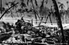 USN October 27, 1943 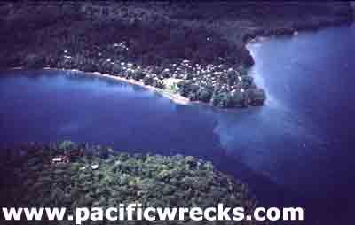 Solomon Airlines 1994 |
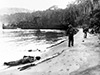
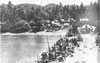
Location Lat 7° 20' 60S Long 155° 34' 0E Mono Island is a large, circular island four miles north to south and six mies wide east to west, part of the Treasury Island Group (Treasury Islands). To the south is Blanche Harbor and and Stirling Island. Heavily forested, with higher ground in the southern portion. Located roughly seventeen miles to the north is Shortland Island. Wartime History Occupied by the Japanese during early 1942. During 1943 the Japanese developed a supply depot on Mono. On June 30, 1943 when American forces landed on nearby Rendova Island the majority of the Japanese withdrew from Mono, leaving only a small spotting station on the island manned by seventeen men. In the middle of 1943, three American aircraft that ditched off the Treasury Islands and seven aircrew reached Mono Island were they where aided by the locals who hid them from the Japanese. The first to arrive on June 22, 1943 were Peck, Teft and Scott of TBF Avenger 47448 that ditched offshore and were hidden by locals. On July 22, 1943 they were joined by King, pilot of P-38G 43-2206. On July 23, 1943 they were joined by Mitchell, Estep, Dahl of TBF Avenger 05923. The seven aviators were hidden by native people. After nearly three months, Peck, Teft, Mitchell and King planned to sail to the south and bring help. On September 13, 1943 the four departed southward aboard one of their life rafts. Five days later, they were spotted and rescued by a PBY Catalina on September 18, 1943. On October 18, 1943 during the night (other sources state the landing was the night of October 21-22, 1943) a U.S. Navy PT Boat landed a coastwatcher scouting party on Mono Island. Using a native canoe the group including Frank Nash, Sgt Bert Cowan, Frank Wickham and Sgt Ilala (Fijian) landed at Lua Point on the east coast of the island. After spending the night on the beach, they made contact with villagers who told them about the three American aviators (Scott, Estep and Dahl) that were hiding on the island. After finding the aviators, they were evacuated with the Coastwatcher party on October 21, 1943 by PT Boat (other sources say night of October 22-23, 1943). Their scouting mission determined there were only roughly 235 Japanese on Mono Island. On the October 25, 1943 during the night, PT boats landed an advance party of New Zealand soldiers and native guides whose mission was to cut Japanese communication lines, prior to the landing. On October 27, 1943 at 6:30am "Operation Goodtime" began when Allied forces began an amphibious landing on Stirling Island. Meanwhile, the New Zealand Army landed the 29th Infantry Battalion and 36th Infantry Battalion at Falamai on southern Mono and caught the Japanese by surprise and quickly overcame resistance. Meanwhile, a detachment from the 34th Infantry Battalion landed at Soanotalu on northern Mono to provide security for a radar station to be established at that location. The Japanese counterattacked against Soanotalu on October 29, 1943 and November 2, 1943. The New Zealander soldiers patrolled the island and conducted mopping up operations until Mono was secure by November 12, 1943. In total, the Japanese lost 223 killed and 8 prisoners. The Allies lost 40 New Zealand Army killed and 145 wounded plus 12 Americans killed and 29 wounded. Falamai (Falami) Small triangular peninsula on the south coast of Mono Island bordering Blanche Harbor, across from Stirling Island, near the Saveke River. Prewar village, site of Allied landing. Soanotalu (Purple Beach) On October 27, 1943 at 6:30am, The "Logan Force" commanded by Major Logan landed on the northern end of Mono at Soanotalu on "Purple beach" at the mouth of the Soanotalu River. This force consisted of New Zealand troops plus some U.S. Navy Naval Construction Battalion "Seabees". On October 29, an attack by roughly 20 Japanese was made on their perimeter, leaving five dead an no Allied casualties. Afterwards, the Japanese probed the line then counterattacked during the night of November 1 by roughly 70-100 Japanese that concentrated a blockhouse command post on the beach. Radar Station Located on high ground on the northeast coast coast of Mono, near Soanotalu. On October 27, 1943 an LCM landing craft with a bulldozer aboard was landed with Ensign John R. Bovyer and his crew. Operators Joe Canada and Grady Thompson cut a road though solid jungle at a 45 degree angle. Afterwards, a radar station was established at this location. References History of U.S. Marine Corps Operations In World War II Bougainville and the Northern Solomons Chapter 1 Plans and Preparations page 14 footnote 68 The Earthmovers (1945) pages 55-60 At Close Quarters PT Boats in the United States Navy (1962) pages 139-140 Lonely Vigil (1977) pages 279- 284 NEITC Chapter 11 - Story of Soanotalu Contribute
Information Last Updated
|
Map Fallingrain Photo Archive |
| Discussion Forum | Daily Updates | Reviews | Museums | Interviews & Oral Histories |
|