|
|
|
|
| Missing In Action (MIA) | Prisoners Of War (POW) | Unexploded Ordnance (UXO) |
| Chronology | Locations | Aircraft | Ships | Submit Info | How You Can Help | Donate |
|
 USN1944 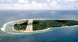 1990 |
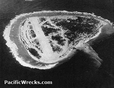
Location Lat 10° 1' 13N Long 139° 47' 24E Falalop Airfield is located in the northern half of Falalop Island in Ulithi Atoll. Prewar and during the Pacific War known as the Caroline Islands. American code named "Ameliorate". Today located in Yap State in the Federated States of Micronesia. Construction During the Pacific War, Japanese forces occupied Falalop Island and moved the local inhabitants off the island to build Falalop Airfield with a single runway spanning the entire width of the northern half of the island oriented east to west. They also constructed shore facilities for Falalop Seaplane Base. By September 1944 abandoned by the Japanese. Wartime History On September 20, 1944 occupied by U.S. Army 81st Infantry Division without opposition. On October 8, 1944 the 8th Naval Construction Battalion (88th NCB) "Seabees" arrive with 797 enlisted men and 28 officers, and was assigned the task of widening, lengthening, and improving Falalop Airfield. Soon afterwards, Marine Air Group 45 (MAG-45) Service Squadron 45 and Headquarter Squadron 45 and arrived on Falalop. Stan Parker, MAG-45 adds: "At the time we landed the island was completely without any type of facilities. A Seabee [88th CB] unit landed with us, and shortly began preparing the island for use as a headquarters base, and air strip. Marine Aircraft Group 45 provided logistics, supplies, maintenance and numerous other facilities for both Navy and Marine aircraft units operating from the airbase. Several Marine Fighter Squadrons, were attached to Group 45 for varying periods of time including VMF(N) 542 (Night Fighter), and VMTB 232. (Torpedo Bomber). Marine Aircraft Group 45 maintained a base of operations continuously until the island was physically disbanded in approximately late October 1945. At that time the island was returned to it's original state with removal of all evidence of occupation, including buildings, equipment etc. Marine Aircraft Group personnel then sailed for the United States, on the troop ship Botetort arriving in San Francisco in late November 1945." After 15 days, the first American aircraft landed at Falalop Airfield. After 27 days of work, the single runway was repaired and measured 3,500' x 150' with the eastern end extended approximately 20' beyond the natural shoreline with log cribs being used as foundation for this extension. Six taxiways were constructed, the first 4,000' x 100', the second 3,250' x 700' and four that were 500' x 100' plus hardstands, lighting, a traffic-control tower, operations buildings, aviation-gasoline ready tanks, and a tank farm. By December 1, 1944 the airfield was completed and fully operational. Pontoon piers installed by the 51st Battalion to be used as aviation-gasoline mooring piers near the main airfield. Also, the 88th Battalion C, D and 1/2 of HQ company built shore facilities. On November 8, 1944 CBMU 603 arrives and begins general maintenance of the airfield and constructed a sewage-disposal system plus a 3,000 man galley, a refrigeration storage building, a butcher shop, an issue room, a bakery an officers’ mess, and shops for a landing craft unit was another important task. Other construction included enlarging and improving a finger pier and the removal of 10,000 cubic yards of coral to improve beaching facilities for landing craft. With the departure of the other battalions, CBMU 603 took over all construction, maintenance, and stevedoring duties until V-J Day. American units based at Falalop VMD-354 (F4U Photo Recon) VPB-23 (PBY) December 7, 1944 - end of war VMF(N) 542 (F6F-3N) October 8, 1944 - February 15, 1945 Okinawa Light Aircraft Strip Between December 12, 1944 to January 27, 1945 another smaller runway was built specifically for light aircraft and liason aircraft operating between the islands in Ulithi Atoll including flights to Mogmog Airfield on Mogmog Island. Today Still in use today as Falalop Airfield. Also known as Ulithi Airport. The single runway is oriented 27/09 measures 3,014' x 76' surfaced with asphalt. Airport code: IATA: ULI. References Thanks to Frank O'Hara for information about VMF(N) 542 Contribute
Information Last Updated
|
Sept 1944 June 1945 Map 2000 Map Fallingrain |
| Discussion Forum | Daily Updates | Reviews | Museums | Interviews & Oral Histories |
|