|
|
|
|
| Missing In Action (MIA) | Prisoners Of War (POW) | Unexploded Ordnance (UXO) |
| Chronology | Locations | Aircraft | Ships | Submit Info | How You Can Help | Donate |
|
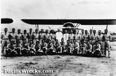 PAAC 1937 
U.S. Army August 15, 1941  Tony Feredo 2000  Justin Taylan 2009 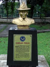 Tony Feredo 2009 |
Location 121° 4' 0" E / 14° 35' 0" N Zablan Airfield (Zablan Field) was located to the east of Highway 54 (EDSA) and Cubao in Quezon City to the north of Manila. Also known as Camp Murphy Airfield or Manila East Airfield. One mile to the east was Zablan Auxiliary Airfield. Construction Built prewar by the U.S. Army at Camp Murphy with a pair of intersecting sod runways adjacent to the parade ground at Camp Murphy. This was the first constructed military airfield manned by the Philippine Constabulary Air Corps (PCAC). Intended primarily for pilot training, the PCAC later became the Philippine Army Air Corps (PAAC) on December 23, 1935. Naming Honors Renamed Zablan Airfield in honor of Major Porfirio E. Zablan, PAAC pilot who died in a plane crash on June 17, 1935. Prewar In 1937, Lieutenant Colonel Dwight D. Eisenhower learned to fly with the Philippine Army Air Corps (PAAC) at Zablan Airfield. On August 15, 1941 at a ceremony in a hangar at Zablan Airfield, the Philippine Army Air Corps (PAAC) was inducted into the U.S. Army and incorporated into the Far East Air Force (FEAF). The ceremony inside the hangar was attended by General Douglas MacArthur, Lt. Col. Richard K. Sutherland, Col. Harold H. George, Lt. Col. William F. Marquat and Major LeGrande A. Diller with Boeing P-26 Peashooter fighters parked outside the hangar. At the time the PAAC consisted of 141 pilots, 17 ground officers, 1,200 enlisted men plus 64 aircraft under Commanding Officer (C.O.) Major Basilio Fernando. The first class of six PAAC students: Alandy, Villamor, Reyes, Zosa, Cruz, Wuirante and Padilla had no uniforms other than overalls and none were accommodated at Zablan, and had to be shuttled to the field using the only four wheel drive vehicle available. Philippine Army Corps Units based at Zablan 6th Pursuit Squadron (P-26A) 1941 Japanese Usage During early January 1942 occupied by the Japanese when they entered Manila. The Japanese expanded Zablan Airfield with two intersecting runways further to the southeast in an inverted L shape. One runway was east to west while the other was north to south. Used by the Japanese Army Air Force (JAAF) fighter aircraft. Japanese units based at Murphy 29th Hiko Sentai (Ki-44, Ki-84) also Zablan Auxiliary Airfield Postwar After the war, it was renamed Camp Emilio Aguinaldo (first president of the Philippines). Since Highway 54 (old name of EDSA) split the Camp Murphy, the other half located on the eastern side of Highway 54 was later named Camp Crame (after Brig Gen Rafael Crame, the first Filipino PC chief), where the Philippine Constabulary was headquartered. Now its the HQ of the Philippine National Police. Today Disused as an airfield since the war, it is now known as "Camp Aguinaldo". Today, it is the national headquarters of the Armed Forces of the Philippines (AFP), located close to the national headquarters of the Philippine National Police (PNP). The former Japanese runways forms the roads of White Plains Avenue and a portion of Katipunan Avenue, just in front of White Plains subdivisions. If you happen to pass by Santolan Avenue, the two concrete water towers fronting the entrance are original since the 1930s. Tony Feredo adds: "I have a photo of Zablan taken from the air which shows the entire compound and reservoir plus a sketch of the Japanese enhanced runways. The hangar is now a basketball court but it was said that it was moved from its original location. I hope its still there up to now." Armed Forces of the Philippines Museum (AFP Museum) Located at General Arturo Enrile Building behind parade ground References Wings Over The Philippines (2008) page 37 Pacific War Airfields Project - Zablan (Camp Murphy, Manila East) Thanks to Tony Feredo for additional information Contribute
Information Last Updated
|
121° 4' E 14° 35' N View in Google Earth (Prewar) Photo Archive |
| Discussion Forum | Daily Updates | Reviews | Museums | Interviews & Oral Histories |
|