|
|
|
|
| Missing In Action (MIA) | Prisoners Of War (POW) | Unexploded Ordnance (UXO) |
| Chronology | Locations | Aircraft | Ships | Submit Info | How You Can Help | Donate |
|
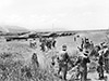 Australian Army September 20, 1943 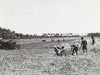 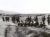 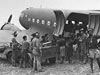 Australian Army September 25, 1943 |
Location Kaiapit Airfield is located to the south of Kaiapit in the Ramu Valley in New Guinea. Prewar and during the Pacific War located in the Territory of New Guinea. Today located in Morobe Province in Papua New Guinea (PNG). Construction Built prior to the war by the Australian administration as a single runway. The single runway measured 1,500 x 100 x 900 yards (4,500' x 300' x 2,700). The facilities included one house, native shacks with excellent unobstructed approaches and native foods (sweet potatoes, bananas, pig) are available. Wartime History During early 1942 occupied by the Japanese but was not used as a military airfield. During September 1943, Kaiapit Airfield was occupied by the Australian Army. Immediately, U.S. Army engineers repaired the runway using bulldozers and native laborers and surveyed the area for expansion for Allied military use. The prewar prewar runway was expanded to 6,000' x 100' and a parallel fighter strip as a second runways. In late September 1943 until early October 1943, C-47s transported Australian Army personnel and supplies including the 21st Infantry Brigade Headquarters from Dobodura to Kaiapit Airfield. Also used by liaison aircraft including L-4 Cubs and L-5 Sentinels. As of January 8, 1944 the U.S. Army ceased further development of Kaiapit Airfield as a military airfield when a new plan of operations deemed it to be unessential to the Allied war effort. Afterwards, the runway remained in use to support the Australian Army until they advanced into the Markham Valley and beyond. References Notes about New Guinea airfields, recorded circa May - July, 1942 by Oliver C. Doan via Jean Doan research Edward Rogers Engineers in Theater Operations [Pacific] "Advance Area Airdromes 31 January 1944", Map No. 24 Contribute
Information Last Updated
|
Map Fallingrain View on Google Earth Photo Archive |
| Discussion Forum | Daily Updates | Reviews | Museums | Interviews & Oral Histories |
|