Missing In Action (MIA)
Prisoners Of War (POW)
Unexploded Ordnance (UXO)
Chronology
Locations
Aircraft
Ships
Submit Info
How You Can Help
Donate
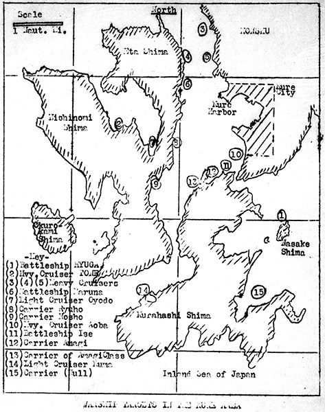
Map of warship targets in the
Kure
area
The map indicates
Kure City
on
Honshū
bordering
Kure Harbor
and
Eta Shima (Etajima)
, Nishinomi Shima, Okuro-kami Shima and Kurahashi Shima and Nasake Shima and beyond the Inland Sea of
Japan
. To the north and west is
Hiroshima Bay
and beyond to the east and south is the Inland Sea. Imperial Japanese Navy (IJN) warship targets key:
(1) Battleship Hyuga
(2) Heavy Cruiser Tone
(3)(4)(5) Heavy Cruisers
(6)
Battleship Haruna
(7) Light Cruiser Oyodo
(8)
Carrier Ryuhō
(9)
Carrier Hōshō
(10)
Heavy Cruiser Aoba
(11)
Battleship Ise
(12)
Carrier Amagi
northeast of Mitsukojima
(13)
Carrier of Amagi Class
[
Katsuragi
] southwest of Mitsukojima
(14) Light Cruiser Kuma
(15) Carrier (Hull)
Credit: USN via VB-87 page 81 Date:
July 24, 1945
Map
High Resolution Version
Acquire This Image
|
Contribute Information
Do you have photos or additional information?
Previous Page
Discussion Forum
Daily Updates
Reviews
Museums
Interviews & Oral Histories
Pacific Wrecks Inc.
All rights reserved.