|
|
|
|
| Missing In Action (MIA) | Prisoners Of War (POW) | Unexploded Ordnance (UXO) |
| Chronology | Locations | Aircraft | Ships | Submit Info | How You Can Help | Donate |
|
 USN c1945 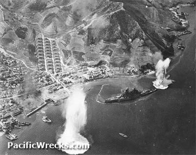  USN July 28, 1945 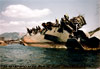 USN March 1946  Williams September 1945 |
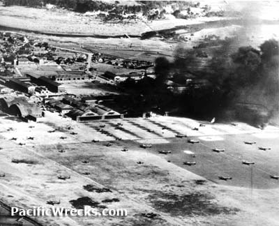
Location Kure Harbor borders Kure inside Hiroshima Bay in Hiroshima Prefecture in the Chūgoku Region of Honshū in Japan. Beyond is the Inland Sea. Offshore is Karahashi-jima, Eta Jima , Nishinomi Shima, Kurahashi Shima and Nasake Shima and Mitsukojima (Mitsugojima). Wartime History Kure Harbor was an important Japanese Navy anchorage. Kure Harbor was dubbed the "Imperial Navy's Harbor". During 1945, targeted by Allied aircraft and subjected to bombing by U.S. Navy (USN) carrier aircraft and U.S. Army Air Force (USAAF) B-29 Superfortress and B-24 Liberators. American missions against Kure and Kure Harbor March 19, 1945–July 29, 1945 Today Kure Harbor is a base for the Japan Maritime Self-Defence Force (JMSDF). Amagi Anchored as anti-aircraft defensive off Mitsukojima sunk July 27, 1945 scrapped 1947. Ise Anchored off Mitsukojima sunk July 28, 1945 scrapped 1947. Haruna Damaged March 19, 1945 in Kure Harbor and scrapped post war. Aoba Damaged July 24–25, 1945 and scrapped 1946–1947. Tone Sunk July 24, 1945 off Nishinomi Shima to the west of Kure Harbor, salvaged postwar and scrapped. I-404 On July 28, 1945 hevily damaged and later scutteld, raised postwar and scrapped 1952. Contribute
Information Last Updated
|
Map July 24, 1945 Warship Targets Map July 28, 1945 Map Fallingrain |
| Discussion Forum | Daily Updates | Reviews | Museums | Interviews & Oral Histories |
|