|
|
|
|
| Missing In Action (MIA) | Prisoners Of War (POW) | Unexploded Ordnance (UXO) |
| Chronology | Locations | Aircraft | Ships | Submit Info | How You Can Help | Donate |
|
 USAAF 1945 |
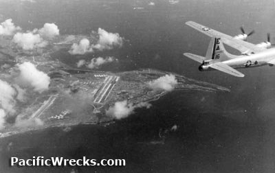
Location Tinian Island is part of the Mariana Island Group (Mariana Islands). Also known as simply "Tinian". The island has an area of approximately 39 square miles. Tinian is roughly the same size and shape as Manhattan. Borders the Saipan Channel and Saipan Island to the north. To the south is Agrihan Island (Aguigan) and Rota Island (Luta). Today located in the Southern Islands Municipality of the Commonwealth of the Northern Mariana Islands (CNMI) in the United States of America (USA). Prewar Tinian was claimed by both Spain and Germany. After World War I, Tinian became a protectorate of Japan. Under the Japanese administration, sugar cane plantations were established. Wartime History Starting in February 1944, Tinian was targeted by U.S. Navy (USN) carrier planes and later U.S. Army Air Force (USAAF) fighters and bombers. By July 1944, the Japanese garrison on Tinian included 9,000 personnel under the command of Imperial Japanese Navy (IJN) Admiral Kakuda. During July 1944 attacked by American bombers and fighters. Starting on July 11, 1944 U.S. Navy (USN) warships bombarded the island for thirteen days ahead of the planned invasion. American missions against Tinian February 23, 1944–August 19, 1944 On July 24, 1944 the U.S. Marine Corps (USMC) 4th Marine Division from Saipan landed at the White Beach sector at Unai Chulu on Tinian. Initially, the Japanese were taken by surprise and the operating was regarded as one of the best-executed amphibious operation of the entire Pacific War. During the initial landing, 1,500 U.S. Navy (USN) Seabees landed and immediately begin repairing Ushi Point Airfield (North Field) before the fighting concluded. On July 26, 1944 the 2nd Marine Division also landed. By August 1, 1944 Tinian was officially declared secure at a cost of 328 Marines killed and 1,571 wounded. The Japanese lost 5,000 dead. As American forces developed infrastructure they laid out roads in the same orientation as Manhattan, New York City because Tinian is roughly the same size and shape. The main north-south road was dubbed "Broadway". Parallel and to the west "8th Avenue". On Tinian, the Americans repaired and expanded Ushi Point Airfield (North Field) with four parallel runways and Gurguan Point Airfield (West Field) with three parallel runways connected by eleven miles of taxiways were built for B-29 Superfortresses to accommodate the entire 313th Bombardment Wing (313th BW) with two additional airfields on Saipan. Bruce Petty adds: "People I interviewed on Tinian, who were relocated there from Yap, told me that they didn't have to farm or do work of any kind for the first two years because the military left entire warehouses full of everything imaginable from food, brand new uniforms, and even ice cream makers. Anybody who wanted a vehicle could just go pick one up and drive it until it fell apart, than go get another one." San Jose Village (Tinian Town) San Jose village is located on the southwest of Tinian bordering Suharon Harbor. During 1944-1945 dubbed "Tinian Town" by Americans. On July 24, 1944 a feign landing was staged off San Jose village by the U.S. Marines 2nd Marine Division that made a mock landing, lowering landing craft with Marines into the sea to confuse or fool the Japanese defenders into believing the invasion force would land in the southwest of Tinian. Meanwhile, the 4th Marine Divison launched the actual amphibious landig on the White Beach Sector of northwest Tinian. White Beach Sector (Unai Chulu) Unai Chulu is located on the northwest coast of Tinian Island. The Americans designated two beaches "White 1" and "White 2" for the amphibious landing by U.S. Marines in late July 1944. Today a Japanese bunker remains on White 1 and a Japanese pillbox on White 2. Ushi Point Located at the northern edge of Tinian includes North Field (Ushi Point Airfield). Gurguan Point Located on the western tip of Tinian West Field (Gurguan Point Airfield) Built by the Japanese occupied by the U.S. and expanded into a base for B-29 Superfortresses Japanese Holdout In 1953, Japanese soldier Murata Susumu was captured. He was living in a small shack near a swamp since the end of the battle on August 1, 1944 and the official surrender of Japan on September 2, 1945. References Marines in World War II Commemorative Series "A Close Encounter: The Marine Landing on Tinian" Contribute
Information Last Updated
|
Map 1945 Map Fallingrain |
| Discussion Forum | Daily Updates | Reviews | Museums | Interviews & Oral Histories |
|