|
|
|
|
| Missing In Action (MIA) | Prisoners Of War (POW) | Unexploded Ordnance (UXO) |
| Chronology | Locations | Aircraft | Ships | Submit Info | How You Can Help | Donate |
|
 U.S. Army prewar 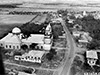 USAAF 1945 |
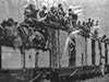
Location Lat 15° 8' 9N Long 120° 35' 28E Angeles is located at an elevation of 335' / 102m in Pampanga Province in Luzon in the Philippines. Previously, known as Culiat. Prewar and during World War II also known as Angeles Town. Today known as Angeles City and is a highly urbanized city in Pampanga Province. Borders Clark Field to the northwest. Prewar The Manila-San Fernando Rail Road Line with a narrow gauge rail road connected San Fernando via Angeles northward to Dagupan. Due to the proximity to the U.S. bases in the area, Angeles became an area with entertainment for military personnel including restaurants, bars, prostitutes and brothels. Wartime History During January 1942 occupied by the Japanese Army until late January 1945. On January 27, 1945 liberated by the U.S. Army 37th Infantry Division, 145th Infantry Regiment. Angeles Airfield Located to the south of Angeles, less developed than other airfields Angeles North Airfield (Angeles N.E.) Located to the east of Highway No. 3 Angeles South Airfield (Lara Airfield) Located to the east of Highway No. 3 Angeles West Airfield (No. 1) Located to the west of Angeles, parallel to Angeles No. 2 Angeles West Airfield (No. 2) Located to the west of Angeles, parallel to Angeles No. 1 Manila-San Fernando Rail Road Line American and Filipino POWs passed through Angeles aboard rail road cars on their way to the POW camp at Camp O'Donnel. During the Japanese occupation, the rail line fell into neglect and disrepair. Today, the tracks are abandoned and still visible in some areas of Angeles. Museum of Angeles (Museu ning Ángeles) Located in Barangay Santo Rosario, the building was built in 1922 and was Angeles town hall until 1998. During 1999, became the Museu ning Ángeles run by the Kuliat Foundation. Outside is a statue of José Abad Santos. The collection includes exhibits on World War II and artifacts found in the area. Holy Rosary Parish Church (Pisamban Maragul) Built in 1877, officially Our Lady of the Most Holy Rosary Parish Church. In Spanish, Iglesia Parroquial de Nuestra Señora del Rosario. Also known locally as Pisambang Maragul (Big Church). On January 7, 1945 Filipinos sheltered in the church during an air raid when damaged B-25J "Sag Harbor Express" 43-36030 left wing hit the roof of the church then crashed in the courtyard nearby. B-25J "Sag Harbor Express" Serial Number 43-36030 pilot Browngardt crashed January 7, 1945 Holy Angel Academy (Holy Angel University) 1 Holy Angel St, Angeles, 2009 Pampanga, Philippines During June 1933, Holy Angel Academy (HAA) was founded as a high school in the Holy Rosary Parish Convent. By 1940, as the school expanded, it moved from the Parish Convent to its first building (present Don Juan D. Nepomuceno Building (DJDN Building). On December 8, 1941 when the Pacific War began in the Philippines, classes were suspended until liberated by the U. S. Army on January 27, 1945. On December 4, 1981 renamed Holy Angel University (HAU). References Destiny and Destination Holy Angel University (2009) by Robert P. Tantingco Contribute Information Do you have photos or additional information to add? Last Updated December 3, 2025 |
Map Feb 1, 1945 Map Fallingrain Map Mapcarta |
| Discussion Forum | Daily Updates | Reviews | Museums | Interviews & Oral Histories |
|