|
|
|
|
| Missing In Action (MIA) | Prisoners Of War (POW) | Unexploded Ordnance (UXO) |
| Chronology | Locations | Aircraft | Ships | Submit Info | How You Can Help | Donate |
|
   Justin Taylan 2005 |
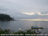
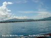
Location Lat 13° 45' 34N Long 121° 3' 36E Batangas is located at an elevation of 22' / 6m above sea level in Batangas Province in southern Luzon in the Philippines. Also known as "Batangas City" and is the capital of Batangas Province. Borders Batangas Bay to the south and the Batangas Mountains to the southeast. Roughly sixty miles to the north is Manila. Wartime History At the start of the Pacific War, Batangas was attacked by Japanese aircraft. After the surrender of the Philippines, occupied by the Japanese during their occupation of the Philippines. Starting in the middle of December 1944, attacked by U.S. bombers and fighters until late April 1945. Japanese and American missions against Batangas December 10, 1941 - April 28, 1945 On March 24, 1945 the 188th Infantry departed Batangas and proceeded eastward towards Mount Malepunyo and the Batangas Mountains. Batangas Airfield Built prewar, used in the defense of the Philippines, abandoned Base R (Camp Batangas) US Army Letter Base designation. Base R (Camp Batangas) was a sub-base controlled by Base M (San Fernando). P-38L Lightning Serial Number 44-25427 Pilot Hill crashed January 31, 1945 References U.S. Army in World War II - Triumph in the Philippines Chapter XXIII pages 423-425, 427, 429, 431, 438, 445 Contribute
Information Last Updated
|
Map Fallingrain |
| Discussion Forum | Daily Updates | Reviews | Museums | Interviews & Oral Histories |
|