|
|
|
|
| Missing In Action (MIA) | Prisoners Of War (POW) | Unexploded Ordnance (UXO) |
| Chronology | Locations | Aircraft | Ships | Submit Info | How You Can Help | Donate |
|
  Justin Taylan July 9, 2024 |
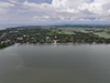
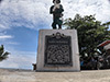
Location Lat 10° 31' 13N Long 122° 48' 6E Pulupandan is located at sea level on the western tip of Negros Occidental Province on the northwest coast of Negros Island in the Western Visayas (Region VI) in the Visayas (Visayas Islands) in the central Philippines. Also spelled Palupandan or Puhipandan. To the southeast is Patik (Patic). To the west is the Guimaras Strait and beyond Guimaras. Wartime History On March 29, 1945 at 5:00am the U.S. Army landed a reinforced platoon from Company F, 185th Infantry Regiment, 40th Divison at Pulupandan without opposition or preinvasion bombardment. The platoon moved inland about three miles to secure a bridge over the Bago River and fought a battle with Japanese guarding the bridge but was able to capture the span and held off counterattacks. Meanwhile, by 9:00am the main body of the 185th Infantry Regiment followed by the 160th Infantry Regiment landed and moved north and eastward. In total, the Americans lost 5 killed and 10 wounded. On April 7, 1945 the U.S. Army 503rd Parachute Regiment (503rd PIR) land at Pulupandan as reinforcements. Pagdaong Sa Pulupandan Memorial with an American soldier atop of concrete block memorializing the March 29, 1945 landing by the U.S. Army 185th Infantry Regiment, 40th Divison at this location. References U.S. Army in World War II - Triumph in the Philippines Chapter XXXI The Central Visayan Islands pages 603 (map), 606 (Pulupandan) Allied Geographical Section Southwest Pacific Area Terrain Study No 99 Negros Island and Siquijor Island (Philippine Series 15th November 1944 pages 15 (Pulupandan), 87 (Map Pulupandan), 127 (photo) Contribute
Information Last Updated
|
Map March 29, 1945 Map Fallingrain Map Mapcarta |
| Discussion Forum | Daily Updates | Reviews | Museums | Interviews & Oral Histories |
|