|
|
|
|
| Missing In Action (MIA) | Prisoners Of War (POW) | Unexploded Ordnance (UXO) |
| Chronology | Locations | Aircraft | Ships | Submit Info | How You Can Help | Donate |
|
  Justin Taylan Sept 2003 |
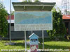
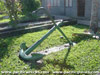
Location Lat 4° 16' 0S Long 144° 58' 0E Bogia is located on the north coast of New Guinea. Borders Bogia Harbor. To the northwest is Hansa Bay. Offshore is Kolakola Island. Today located in Madang Province in Papua New Guinea (PNG). Wartime History During 1943 occupied by the Japanese Army and used as an outpost area between the larger bases of Hansa Bay and Madang. By May 1944, the remaining Japanese forces in the area withdrew northward as the Australian Army advanced from the south. Starting in late March 1943, attacked by Allied bombers and fighters until early May 1944. Allied missions against Bogia March 27, 1943–May 2, 1944 Bogia District Administrative Headquarters Outside, there is an anti-aircraft gun and anchor on display. They were brought to Bogia in 1975 for PNG independence for display at the district headquarters for this area of Madang Province. Type 88 75mm Anti-Aircraft Serial Number 2582 (Bogia No. 1) Recovered from the Awar area. Type 88 75mm Anti-Aircraft Gun (Bogia No. 2) Recovered from the Awar area, no serial number is visible. P-70A Havoc 42-33143 Pilot 2nd Lt. Robert M. Forrestal crashed April 2, 1944, 1 recovered, 1 missing Contribute
Information Last Updated
|
Map Fallingrain |
| Discussion Forum | Daily Updates | Reviews | Museums | Interviews & Oral Histories |
|