|
|
|
|
| Missing In Action (MIA) | Prisoners Of War (POW) | Unexploded Ordnance (UXO) |
| Chronology | Locations | Aircraft | Ships | Submit Info | How You Can Help | Donate |
|
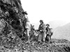 AWM July 18, 1943 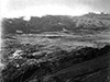 AWM Feb 24, 1944 |
Location The Bulldog Track was a prewar walking track in southern New Guinea that was upgraded into a road that begins at Bulldog (Bulldog Base) along the Lakekamu River then follows the Aiu Avi River then turns to the northeast crossing the central mountain range and ends ending at Kudjeru with other trails connecting to Wau. After the Australian Army built a vehicle road it became known as the "Reinhold Highway", "Bulldog Road", "Bulldog-Wau Road" or "Wau-Bulldog Road". Today, Bulldog Track spans from Gulf Province to Morobe Province in Papua New Guinea (PNG). The Bulldog Track (prewar-1943) began at Bulldog (Bulldog Base) in the southwest side in Gulf Province following the Eloa River to the northeast crossing the central mountain range. On northeast side in Morobe Province ended at Kudjeru (Kudjuru) with a track connecting northward to Winima, Blakes Camp, Wuri Wuri, Kaisenik (Kaisinik) and then to Wau. The Bulldog Road (1943-1944) southwest side in Gulf Province includes: Bulldog (Bulldog Base) with a Bulldog Trail Railway (Tram Line) from following the Eloa River to the northeast past Dead Chinaman Camp to Fox Camp (named after Captain Charles W. G. Fox), Centre Camp (The Centre Camp) and the Eloa River Crossing at the start of the Koluron Mountains with switchbacks then onward to Bannon Lookout (Bannon's Lookout overlooking the Eloa River Valley) then Fox Saddle (Fox Gap named after Captain Charles W. G. Fox) then to Ecclestone Saddle (Eccleston Gap named for Captain J. W. Ecclestone) into the Hidden Valley to Johnson Gap passing the Kaindi Range to Torr's Lookout (roughly 4 miles from Edie Creek), Edie Creek crossing Clowes Creek then to Wau. Prewar The Bulldog Track was a walking trail used by local people to cross the mountains. On the northern side of the Bulldog Track began at Kudjeru in the Bulolo Valley. On the southern side of the Bulldog Track was Bulldog. Wartime History At the start of the Pacific War, the Bulldog Track was only suitable for walking or mules and roughly followed the Edie Creek. This track was deemed to be more difficult: longer, steeper, higher elevation and rougher than the more famous Kokoda Trail roughly 100 kilometers to the east. In late January 1942 after Japanese aircraft attacked New Guinea, gold miners and civilians from Wau, Bulolo and Edie Creek trekked the Bulldog Track over six weeks, some carrying gold or gold dust they mined. It took the civilians roughly six weeks to reach the Motu Motu on the southern coast. During early March 1942, Australian Army Captain Allan Cameron and his men withdraw from Salamaua Airfield via Wau walking southward over the Bulldog Track on the south coast. In late March 1942 or early April 1942 Royal Australian Air Force (RAAF) F/O Wilbur Lawrence Wackett who bailed out P-40E Kittyhawk A29-6 was aided by by two native Police Boys trekking from Wau via the Bulldog Track then to the south coast and returned to Port Moresby. In early 1942, the 30 commandos of the 1st Independent Company (1st Ind Coy) under the command of Captain Roy Howard trekked the Bulldog Track northward and joined the "Kanga Force" comprised of the New Guinea Volunteer Rifles (NGVR) and the 2/5 Independent Company commandos at Wau. To support the "Kanga Force" under the command of Lt. Col Fleay, Papuan carriers hauled supplies from Bulldog over the Bulldog Track to Kudjeru, where the cargo was loaded onto mules then distributed. In late June 1942 to early July 1942, war photographer and cinematographer Damien Parer with journalist Osmar White embarked aboard schooner Royal Endeavour to the mouth of the Tauri River then used two large canoes to paddle up the Lakekamu River to Bulldog. The pair walked the Bulldog Track with Australian Army soldiers including Cpl Dick Paul and Cpl Vic Helton plus native carriers to the northeast across the central mountain range to Kudjeru where they linked up with Australian Army commandos then continue to Wau. During his trek, Parer recorded 35mm cine footage along the track and recorded notations in small notebooks that were later expanded into dope sheets when he later returned to Port Moresby. Parer's footage was edited into a Movietone newsreel "The Most Amazing Supply Route". On July 3, 1942 a patrol from the 1st Independent Company including F. J. Vidgen, Captain C. W. G. Fox (a prewar surveyor), Cpl P. M. Swanson, Sapper J. Cribb, three New Guinea police officers plus over fifty native porters depart Kudjiru and began a survey of the Bulldog Track for development into a road. During August 1942, Captain Fox continued to survey the area for the best route for a road. He was accompanied by Captain J. Eccleston, who lived in New Guinea prewar, Sgt Bannon and Cpl Swanson. They concluded the best route followed the approximate course of the Eloa River. Meanwhile, another reconnaissance party departed Port Moresby to the Lakekama River and began establishing staging camps along the track for further development. By late August 1942, as the Japanese Army advanced from Salamaua to Mubo, "Kanga Force" was refused reinforcements due needs along the Kokoda Trail and at Milne Bay. Panicked, During early September 1942, the "Kanga Force" under the command of Lt. Col Fleay ordered the withdrawal from Wau southward to Kudjeru, dubbed the "Bulldog Stakes" or "Bulldog Derby". At least 80 soldiers began retreating down the Bulldog Track but were ordered to halt and return. By September 1942, Papuan carriers were delivering 40 carrier loads per day across the track and continued to be the primary method of resupply for "Kanga Force" until January 1943 when C-47 Dakotas began using Wau Airfield. In November 1942, General Blamey approved a secret plan to expand the Bulldog Track into the Bulldog Road for vehicles. There were plans to extend the trail all the way to the coast but this was never realized. In January 1943 Royal Australian Engineers Lt. Col. William James Reinhold, 11th Australian Division was assigned the task of surveying a route for the Bulldog Road. On January 12, 1943 Lt. Col. Reinhold led a survey team including Captain Maynes that departed Bulldog Camp and walked the Bulldog Track northeast to Kudjeru. They concluded that a better route was needed for the road, ideally to link up with the Wau-Eddie Creek Road. On the southern side of the range a route had to be found to Eloa River gorge a canyon with cliffs on both sides described by Reinhold as "It is a barrier that has to be seen to be believed." These surveys led to the conclusion that the Bulldog Road would connect Fox Saddle to Centre Camp. During the middle of 1943, to facilitate the movement of supplies the Australians built the Bulldog Trail Railway (Tram Line) spanning from the barge unloading point at Grim Point (Kunimaipa) to the northeast to Bulldog (Bulldog Base). By early September 1943, the railway was abandoned due to a shortage of rails, rolling stock and difficult terrain including sink holes in the sago swamp. The construction force included 2/1st Australian Field Company and 2/16 Field Company augmented by native laborers and carriers began expanding the track from Bulldog to the northeast. Also supporting was the 1st Australian Pack Transport Company and 3rd Australian Pack Transport Company. Demolition of rock faces was performed by sappers from the 9th Australian Field Company. Reinhold described the construction "Every foot of progress made on this road exacted the ultimate in courage, endurance, skill and toil. Its construction took a toll from surveyor, engineer, labourer and native carrier alike." By April 1943 the Japanese were aware of the Bulldog Track and Bulldog Road construction. On April 18, 1943 seven natives from Kerema reached Lae and reported they were conscripted by the Australian Army to work on the Bulldog Road. On April 22, 1943 a Japanese reconnaissance airplane spotted an eight meter wide road (two lanes) practically completed from Bulldog to Kudjeru. By late May 1943 they were also aware of the new Bulldog Road being built from native informants captured at Hote. On June 2, 1943 Japanese launched an air raid against Bulldog and Bulldog Airfield that caused minimal damage but caused 500-700 natives in the area fled in fright, disrupting construction and labor. Meanwhile, Captain John W. Eccleston a prewar New Guinea administrator was tasked with surveying a route from Edie Creek southward over the Koluron Mountains with a crossing dubbed "Eccleston Saddle" or "Ecclestone Gap" at an elevation of 8,514' / 2,900m. During construction, Eccleston was responsible for construction from Steel Falls to Edie Creek. The highest elevation was named in his honor "Eccleston Saddle" or "Ecclestone Gap" with an elevation of 8,514' / 2,900m. On July 15, 1943 at a conference, Australian Army Major General Frank Berryman made a friendly bet with U.S. Army Air Force (USAAF) General Kenney that a jeep would cross the road by August 1, 1943 (he lost). Kenney dubbed the project "this damn Wau-Bulldog road" and rightfully believed air transport was the key in New Guinea. During the six months of construction, more than 70% of the Australians contracted malaria. In total, the project took nine months of construction and roughly 1,038 Australian engineers and 1,825 Papuans laborers supported by 524 Papuan carriers to build the road. During construction, only four Australians were killed; one by a landslide, one by a falling tree and two by accidental explosions. Locals from the Kukuku (Kukukukus) tribes of pygmy people sometimes raided camp areas and stole axes, knives, and explosives. By late August 1943, the completed road became known as "Reinhold Highway" and spanned 140 miles with vehicles traveling at an average speed of 8-10 mph with truck convoys. Between August 23-25, 1943 the inaugural vehicle convoy including trucks and jeeps from the Royal Australian Engineers, headquarters led by Lt. Col Reinhold departed from The Centre Camp to Wau spanned 68 miles. When completed, General Sir Thomas Blamey claimed the Bulldog Road "It ranks with the great army engineering feats of history." On September 23, 1943 the first truck convoy traveled across the road that spanned 114 kilometers crossing 17 bridges some with multiple spans. For the remainder of 1943 until at least late February 1944 vehicle convoys from the 2/34th General Transport Company. The Reinhold Highway used mileage markers to indicate distances starting from the northern end at mile zero. Distance markers included: 5 1/2 miles overlooking Wau Valley, 21 1/2 miles and 23 mile. In April 1944, the existence of this road was first revealed in the Australian press. Postwar Afterwards, the road was disused and reverted to a local walking track. By the 1970s, portions collapsed but is still walkable to this day. Today The Bulldog Track is deteriorated but still used as a walking trail. It is considered a challenging walk only to be attempted with local carriers and support. References WW2 Nominal Roll - William James Reinhold QX34507 (Q119519) WW2 Nominal Roll - Charles Wilfred George Fox P454 WW2 Nominal Roll - John William Ecclestone NG3501 Movietone "The Most Amazing Supply Route" cine footage by Damien Parer late June to early July 1942 AWM "War Supply Route" F01213 AWM Feathery fine bamboo ART92271 AWM Cossey, Peter (Lieutenant) PR00217 "Compilation of records (official, private, printed), relating to the experiences of 1st Reinforcements to No.1 Independent company in New Guinea February-July 1942. Covers Port Moresby, Bulldog Track, Wau, Lae, Salamaua areas. Discusses observation of and contact with Japanese forces at this early stage of the campaign in New Guinea" The Sydney Morning Herald "Building The Bulldog Road An Australian Engineering Triumph" May 20, 1944 The Bulldog-Wau Road (1946) by W. J. Reinhold Australia in the War of 1939–1945: Series One: Army Volume 5 (1959) Chapter 18 Wau pages 536, 544, 578, 579 (map), 580-581, footnote 90 End of the Line (1997) pages 90 (map, PNG), 99, 101 (map), 104 (footnote 29, N. Roberts Villagers at War page 58), 164 (appendix, list of rail roads: Bulldog), 167 (index Bulldog) Damien Parer's War (2003) by Neil McDonald pages 174, 180, 182-183, 208, 363 (index Bulldog Camp) The Battle for Wau (2008) by Phil Bradley pages 16, 17, 45, 50, 52, 56, 57, 70, 276 (index Bulldog) To Salamaua (2010) by Phil Bradley pages 40, 95, 96 (map), 97-100, 105, 362 (index Bulldog Road) Wau 1942–1943 (2010) by Phil Bradley pages 6, 12, 20, 33, 43, 168, 213 (index Bulldog) Hell's Battlefield (2012) by Phil Bradley pages 26, 39, 223, 486 (index Bulldog) D-Day New Guinea (2019) by Phil Bradley: "At a conference on 15 July Major General Berryman observed that ‘Our American friends were very pessimistic about our Bulldog–Wau project.’ Berryman bet General Kenney a bottle of whiskey that a jeep would go over the route by 1 August but he would lose that bet: the first jeep convoy did not traverse the road until 23 August. The Americans were right: ‘this damn Wau-Bulldog road’, as General Kenney called it, was a white elephant. It would be air transport that would sustain the Markham and Ramu Valley campaigns and it was always going to be.” Thanks to Phil Bradley for additional information Contribute
Information Last Updated
|
Map Tram Line 1944 Map Bulldog Road 1944 Photo Archive |
| Discussion Forum | Daily Updates | Reviews | Museums | Interviews & Oral Histories |
|