|
|
|
|
| Missing In Action (MIA) | Prisoners Of War (POW) | Unexploded Ordnance (UXO) |
| Chronology | Locations | Aircraft | Ships | Submit Info | How You Can Help | Donate |
|
 Justin Taylan 2005 |
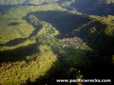
Location Lat 9° 7' 53S Long 147° 40' 22E Kagi is located at an elevation of 5,029' / 1,532m on the Kokoda Trail in the Owen Stanley Range in New Guinea. Also spelled Kage. To the south is Efogi. To the west is Mount Victoria and to the east is Myola. Prewar and during the Pacific War known as the Central District of the Territory of Papua. Today located in Central Province in Papua New Guinea (PNG). Wartime History During August 1942, Kagi was used as a drop zone by Allied transports air dropping supplies to the Australian Army personnel in the area. On September 4, 1942 the Australian Army including A company and B company under the command of Lt. Col Copper retreated southward from Kagi. During late September 1942 occupied by the Japanese Army during their advance southward. Afterwards, targeted by Allied aircraft that strafed and bombed the area. Allied missions against Kagi August 12, 1942–October 1, 1942 In early October 1942 the Japanese began their withdrawal northward via Kagi. On October 12, 1942 Kagi was re-occupied by Australian forces and the Australian 2/25th advanced through Kagi. Today Although it had a limited role during the Kokoda campaign, used by trekkers crossing the trail as a stopover location or way point on treks. Some, trekkers fly into Kagi Airfield then walk the Kagi-Kokoda portion of the trail. Kagi Airfield Postwar airfield. A civilian crashed near this airstrip in the 1980s Bogus 'Body' Hanging in Tree During late August 2008, a report from Kokoda Trail trekkers claimed they had seen 'the body of an airmen in a parachute hanging in a tree' . Australian authorities investigated and found the report to be bogus. Contribute
Information Last Updated
|
Map Fallingrain |
| Discussion Forum | Daily Updates | Reviews | Museums | Interviews & Oral Histories |
|