Missing In Action (MIA)
Prisoners Of War (POW)
Unexploded Ordnance (UXO)
Chronology
Locations
Aircraft
Ships
Submit Info
How You Can Help
Donate
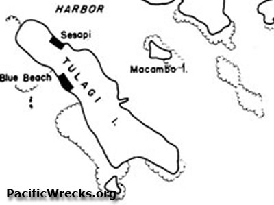
Map of
Tulagi Island
,
Tulagi Harbor
and
Macambo Island
Indicated are
Tulagi Island
,
Blue Beach
and
Sesapi
. To the east is
Macambo Island (Macambo)
to the north is
Tulagi Harbor
and beyond
Florida Island (Nggela Sule, Big Gela)
. To the south is Mbangai Island
Tulagi PT Boat Base
had shore facilities at
Sesapi
on
Tulagi Island
and
Macambo Island
.
Credit: USN Date: 1943
Map
Enlargement
High Resolution Version
Acquire This Image
|
Contribute Information
Do you have photos or additional information?
Previous Page
Discussion Forum
Daily Updates
Reviews
Museums
Interviews & Oral Histories
Pacific Wrecks Inc.
All rights reserved.