|
|
|
|
| Missing In Action (MIA) | Prisoners Of War (POW) | Unexploded Ordnance (UXO) |
| Chronology | Locations | Aircraft | Ships | Submit Info | How You Can Help | Donate |
|
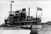 Marin Clemens c1939 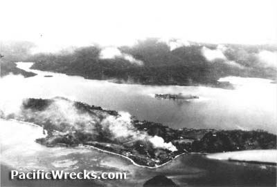 USN August 7, 1942  USN December 12, 1942 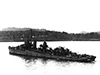 USN July 6, 1943 |
Location Tulagi Harbor is located between Tulagi Island to the south, Macambo Island to the southeast and Florida Island (Nggela Sule, Big Gela) to the north and Iron Bottom Sound to the south. Also known as "Tulagi Roads" or "Tulagi Anchorage". Prewar and during the Pacific War part of the British Solomon Islands Protectorate (BSIP). Today located in Central Province in the Solomon Islands. Prewar The British colonial government was based on Tulagi to administer the British Solomon Islands Protectorate (BSIP). During the prewar era, a small number of Japanese worked on the island in marine industries. Their presence and "yellow peril" sentiments led to the suspicion they were spies and were closely monitored. Before World War II, the Royal Navy (RN) surveyed Tulagi Harbor as a possible anchorage for the Asiatic Fleet and recommended developing this area as a naval base but the recommendation was never acted upon. A small force of Australian Army commandos defended Tulagi Island and Royal Australian Air Force (RAAF) personnel operated Tulagi Seaplane Base from Gavutu Island and Tanambogo Island. On January 22, 1942 the first Japanese aircraft first bombed Tulagi and another air raid happened in early May 1942. Coastwatcher Gordon Train married to Vera Atkinson stayed behind on Tulagi and was lost on a flight to the Shortland Island to warn of the imminent Japanese invasion. On May 2, 1942 the Australian personnel and commandos were ordered to begin demolition of facilities then evacuated aboard two small boats bound for Port Vila in New Hebrides. Wartime History On May 3, 1942 during "Operation MO" the Imperial Japanese Navy (IJN) including Okinoshima, Kikuzuki, Yuzuki, Azumasan Maru, minelayer Koei Maru, subchasers Toshi Maru No. 3 and Tama Maru No. 8, WA-1 and WA-2, Hagoromo Maru, Noshiro Maru No. 2 and Tama Maru enter Tulagi Harbor and lands the 3rd Kure Special Naval Landing Force (3rd Kure SNLF) without opposition on Tulagi, Gavutu and Tanambogo. Afterwards, the Japanese establish Tulagi Seaplane Base and use Tulagi Harbor as an anchorage. Starting May 4, 1942 targeted by Allied bombers and fighters until the U.S. landing on August 7, 1942. American aircraft bombed Tulagi. On August 7, 1942 Tulagi Harbor and the adjacent areas including Purvis Bay were used by the U.S. Navy (USN) as an anchorages for warships and transports for the Guadalcanal campaign then operations in the Solomon Islands. Tulagi PT Boat Base was established with two locations: Sesapi on Tulagi Island and Macambo Island. Shore facilities were built on Florida Island (Nggela Sule, Big Gela). Used by the Allies until the end of the Pacific War. On April 7, 1943 during Operation I-Go Sakusen ("A" Operation: X Attack) Japanese planes strike the Tulagi anchorage and D3A Val dive bombers score hits and near misses that sink HMNZS Moa (T233), USS Erskine M. Phelps (YON-147) and USS Kanawha (AO-1). At 9:35pm damaged USS Aaron Ward (DD-483) sinks near Tulagi. Bow of USS Minneapolis (CA-36) During early December 1942 the damaged bow was cut off the damaged crusier and sunk into Tulagi Harbor. PBY-5 Catalina Bureau Number 04513 Pilot Doyle crashed November 18, 1942 PBY-5 Catalina Bureau Number 08246 Pilot Allen crashed July 12, 1943, 7 missing Contribute
Information Last Updated
|
Map 1943 Map 1943 Detail |
| Discussion Forum | Daily Updates | Reviews | Museums | Interviews & Oral Histories |
|