|
|
|
|
| Missing In Action (MIA) | Prisoners Of War (POW) | Unexploded Ordnance (UXO) |
| Chronology | Locations | Aircraft | Ships | Submit Info | How You Can Help | Donate |
|
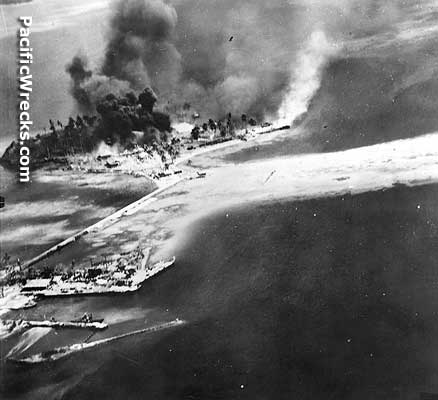 USN August 7, 1942  Steichen August 1942 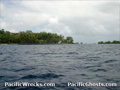 Justin Taylan 2003 |
Location Gavutu Island is located in Gavutu Harbor connected by a causeway to Tanambogo Island in the Florida Island Group (Florida Islands). To the east is Tulagi and to the north is Palm Island (Gaomi) and beyond Florida Island (Nggela Sule, Big Gela). Many references to this base call it the seaplane base at "Tulagi", but in fact it was located on Guvutu. Also, the base was sometimes called "Tanambogo Seaplane Base" for the nearby island connected by causeway. The Japanese referred to this location as "Gabutsu". Also known as "Gavutu Seaplane Base". Prewar and during the Pacific War part of the British Solomon Islands Protectorate (BSIP). Today located in Central Province in the Solomon Islands. Wartime History On January 22, 1942, Japanese aircraft bombed the island. The first shots of the Pacific War were fired in the Solomon Island when the Solomon Islands Defense force member Fala opened fire on the attacking aircraft. On March 29, 1942 resupplied by MV Wanaka that docks at the wharf on Gavutu to delivers a crash boat for RAAF Marine Section for the Tulagi Flying Boat Base along with 1,000 drums of aviation fuel and general supplies. On May 5, 1942 a Japanese flying boat attack Gavutu and sank the RAAF crash boat. That same day, Gavutu Island was occupied by the Imperial Japanese Navy (IJN) 3rd Kure Special Naval Landing Force (3rd Kure SNLF). Afterwards, Gavutu became the main Japanese base in the Florida Islands. Occupied by 536 Japanese naval personnel from the Yokohama Kokutai and 3rd Kure Special Naval Landing Force, plus Korean laborers and Japanese civilians from 14th Construction Unit. Flying boats and seaplanes of the Yokusuka Kokutai and Yokohama Kokutai operated offshore Guvutu and Tanambogo, moored on buoys in two lines. Japanese and American missions against Gavutu January 22, 1942–August 7, 1942 Japanese units based at Gavutu (IJN 25th Flotilla) Yokusuka Kokutai (detachment Mavis, A6M2-N Rufes) Yokohama Kokutai (detachment Mavis) arrived from Rabaul April 1942 3rd Kure Special Naval Landing Forces Tulagi Seaplane Base (Gavutu, Gabutsu) Prewar seaplane base at Gavutu and Tananbogo used by RAAF, Japanese until captured by U.S. Marines A6M2-N Rufe Wreckage Wreckage of at least two destroyed August 7, 1942, salvaged by US Navy and taken to USA On August 7, 1942 in the morning U.S. Navy (USN) carrier planes claimed seven large flying boats (H6K Mavis) as burned in Gavutu Harbor while warships bombarded the island, damaging the seaplane ramp and installations. Landing craft land the U.S. Marines Corps (USMC) 1st Paratrooper Battalion. The original force missed the small (about 30 yard across) "bay" or slipway area, which is adjacent to the north east slope of the hillock and land about 30 yards north of the "bay" in along a straight piece of the coastline 30–40 yards long, and the water laps a low bank, and the Marines were immediately pinned down by gunfire for some time. Defending, the Japanese were entrenched in caves and bunkers and fought fanatically until eliminated. During the Battle of Gavutu, the Marines were accidentally shelled and bombed by friendly forces. On August 8, 1942 at 10:00am the 3rd Battalion 2nd Marines (3/2) land about a third of the way down the eastern side of Gavutu and helps secure the island, then prepared to attack Tanambogo. After the battle, Gavutu was known as "Gavutu Base". Steel arch-rib buildings were erected for shops and two 10,000 barrel aviation gasoline tanks were built in a hillside to concealed them. An existing concrete wharf, 125' by 150' providing 20-foot-draft berthing space, was repaired and a marine railway line was added. By August 1943, these facilities were essentially complete. During December, the U.S. Navy (USN) 34th Naval Construction Battalion (34th NCB) "Seabees" installed a second marine railway on Gavutu and doubled the capacity of the boat nest for small landing craft. The boat nests consisted of rows of piling driven in 50' squares with heavy steel mooring cables stretched across the top of the piles. Supporting facilities were also built on Gavutu including a 10,000 barrel diesel fuel tank on Tanombago and Palm. Today Remains of buildings, storage tanks and underground bomb shelters are visible on the island. Hill 148 (Observation Post) On August 7, 1942 around 2:00pm U.S. Marines took this hill top position and began clearing the Japanese from positions on the hill, with explosive charges, grenades, and hand-to-hand combat, and lay down suppressive fire on positions on Tanambogo. Morris Hill reports: "From the top of the hill, I could see very little of the island because of the height of the surrounding trees. I do remember the large water tank - which used to have roof over it to collect rainwater for Levers and what looks like a anti aircraft mounting for, probably, a heavy machine gun. There was also a very narrow Japanese made tunnel - that went from the top very steeply down about 50 feet - to come out on the side facing Savo. I have a Marine pen friend who spent quite a few weeks manning the observation post on hill 148. His accommodation was on Gavutu - close to the base of the causeway. He did tell me that for a few weeks the men thought there may have been Japanese on the island, but no live Japanese were seen 24 hours after the landing." Lever Brothers Wharf Prewar, the Lever Brothers used Gavutu as a main base of operations. On August 7, 1942 Marines used this concrete wharf for cover during the invasion. After the island was secured, the US Navy repaired and used this wharf. The breakwater and the jetty are formed from concrete blocks and still remains to this day. Today, war time detritus is to found dumped in the sea near this wharf. Further offshore in deeper water are the wrecks of several US landing barges. Gavutu Cemetery During August 1942 Gavutu Cemetery was established on Gavutu Island for U.S. dead from the Battle of Gavutu. Nearby was a Lever Brothers plantation building and perimeter of the cemetery was a low wall made of pieces of concrete. Later, all graves were exhumed and consolidated to other cemeteries in the Philippines and United States. Today, no U.S. graves remains on the island. References USN Building the Navy's Bases in World War II [Chapter 25] page 254-255 Contribute Information Do you have photos or additional information to add? Last Updated February 6, 2026 |
Map July 1942 Map August 1942 Map 1943 |
| Discussion Forum | Daily Updates | Reviews | Museums | Interviews & Oral Histories |
|