 |
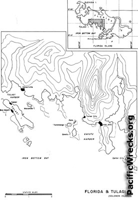
Map of southern Florida Island and bordering Iron Bottom Sound
The map includes: Florida Island (Nggela Sule, Big Gela), Tulagi Harbor, Tulagi Island, Sesapi, Macambo Island bordering Iron Bottom Sound. To the east is Gavutu Harbor, Gavutu Island, Tanambogo Island and Palm Island ofshore Florida Island (Nggela Sule, Big Gela) with Halavo (Balava), Turner City, Carter City and Purvis Bay (Tokio Bay). Upper right Map of the Florida Island Group.
Credit: USN Date: 1943
Map
High Resolution Version
Acquire This Image |
Contribute Information
Do you have photos or additional information?
Previous Page
|
|