|
|
|
|
| Missing In Action (MIA) | Prisoners Of War (POW) | Unexploded Ordnance (UXO) |
| Chronology | Locations | Aircraft | Ships | Submit Info | How You Can Help | Donate |
|
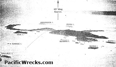 17th PRS January 5, 1943  USAAF Nov 18, 1943  Yoji Sakaida 2005 |
Location The Fauro Island Group (Fauro Islands) is located in Western Province in the Solomon Islands. To the west is the Shortland Island Group (Shortland Islands). Borders the Solomon Sea. Fauro Island Group (Fauro Islands) Fauro Island largest island in the Fauro Island Group Kareki located on the eastern coast of Fauro Island Toumoa located on the southern coast of Fauro Island Kavakava Bay borders the west central side of Fauro Island Asie Island located to the northwest of Fauro Island Tomase Island small island northwest of Fauro Island Benana Island small island to the west of Fauro Island Munia Island small island southeast of Fauro Island Rofei Island (Rohae) small island southeast of Fauro Island Ovau Island located between Bougainville and Fauro Island Nusave Island located west of Fauro Island Piedu Island (Piru) located east of Fauro Island Masamasa Island located east of Fauro Island References Solomon Islands Government Topographic Map 1:50,000 "Fauro Island, Solomon Islands 0615609 X715 Edition 1-SI50K"information as of 2003, printed 2007 Solomon Islands Government Topographic Map 1:50,000 "Oema Island, Solomon Islands 0615609 X715 Edition 1-SI50K" information as of 2003, printed 2007 Contribute
Information Last Updated
|
| Discussion Forum | Daily Updates | Reviews | Museums | Interviews & Oral Histories |
|