|
|
|
|
| Missing In Action (MIA) | Prisoners Of War (POW) | Unexploded Ordnance (UXO) |
| Chronology | Locations | Aircraft | Ships | Submit Info | How You Can Help | Donate |
|
 USAAF 1944 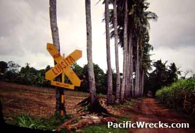   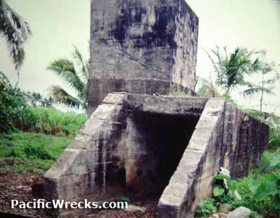 David Mason 2000 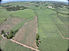 Justin Taylan 2024 |
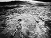
Location Manapla Airfield was located half a mile north of Barrio Caduha-an (Caduhaan) near Cadiz and Hacienda Luisita and Hacienda Carolina in Negros Occidental Province on Negros Island in the Western Visayas Region (Region VI) of the Philippines. The airfield was located roughly two miles inland from the northern coast of Negros. To the south is Highway 1 and to the southeast is Caduhaan (Kaduhaan). Known to the Japanese as Manapla Airfield for Manapla (Manapala) to the southwest. Known to the Americans as Carolina Airfield. Prewar This area was part of the Hacienda Luisita sugar cane plantation with a narrow gauge railroad with carts to transport the sugar cane from the fields to a nearby refinery to be processed into sugar. Construction During late 1942, built by the Japanese as a single runway oriented northeast to southwest that measures 4,040' x 520' surfaced with grass for all weather use and spanned from Hacienda Carolina to the border of Manapla. The runway was usable to 4,800'. The only structure built nearby was a concrete bunker beside the runway used as a command center and air raid shelter. The airfield had several taxiways and revetments. The Japanese used sugar cane plantation narrow gauge railroad carts to transport fuel and bombs from Manapla (Manapala) inland to the airfield. Wartime History Starting in October 1944, Manapla Airfield (Carolina) was used by the Japanese Army Air Force (JAAF) fighters. By Japanuary 1945 all units had withdrawn. Japanese units at Manapla (Carolina) 1st Hiko Sentai (Ki-84) arrives October 1944–November 1944 22nd Hiko Sentai (Ki-84) arrives October 1944–December 44 30th Hiko Sentai (Ki-43IIb and III) arrives August 1944–September 1944 55th Hiko Sentai (Ki-61) arrives December 1944–January 1945 71st Hiko Sentai (Ki-84) arrives December 1944–January 1945 Starting in the middle of November 1944 targeted by American bombers and fighters until the middle of January 1945. American missions against Carolina Airfield November 15, 1944–January 19, 1945 On January 7, 1945 in the morning Ki-84 Frank pilot Sgt Mizunori Fukuda took off from Carolina Airfield armed with a 150 kg bomb on a patrol mission and intercepted a flight of P-38 Lightnings after Ki-43 Oscar pilot WO Sugimoto engaged them. Returning with battle damage, his landing gear leg collapsed and crash landed upside down. Afterwards, he was hospitalized and sent to Japan to recuperate. By April 1945 liberated by the U.S. Army. At Carolina Airfield, Allied Technical Intelligence Unit (ATIU) noted the wreckage of seven Ki-43-II Oscars, three Ki-43-III Oscars, forty-six Ki-84 Franks, one Ki-46-III Dinah, three Ki-49 Helens and one Ki-36 Ida. Today Disused as an airfield since the Pacific War. Today sugar cane fields. Narrow Gauge Rail Road and Carts Prewar narrow gauge railroad line and carts were used until the early 2000s then removed and replaced by trucks. Command Center Bunker The remains of concrete fortification built by the Japanese as a command center are still standing. This was the only permanent building at the airstrip, and was covered in earth to hide it from observation. HO-5 20mm Cannon Found near Carolina Airfield and displayed at a private residence. References Allied Geographical Section Southwest Pacific Area Terrain Study No 99 Negros Island and Siquijor Island (Philippine Series 15th November 1944 pages 202 (photo), 203 (photo), 261 (photo) ATIU Intelligence Summary No. 281 "Planes Recovered on Airfields" July 21, 1945 page 27 via Tony Feredo "Carolina A/D, Negros: Oscar 2 - 7, Oscar 3 - 3, Frank - 46, Dinah 2 -1, Helen -3, Ida - 1" Thanks to David Mason and Tony Feredo for additional information Contribute
Information Last Updated
|
Map Jan 7 1945 Map 1970s Map Fallingrain Photo Archive |
| Discussion Forum | Daily Updates | Reviews | Museums | Interviews & Oral Histories |
|