 |
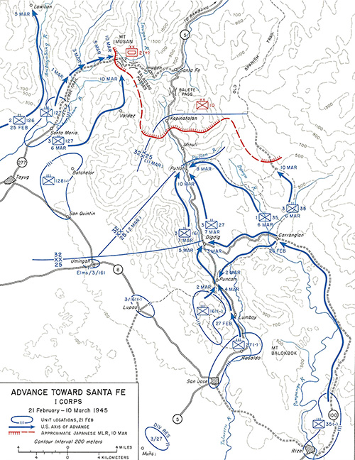
Map of Advance Towards Santa Fe I Corps 21 February–10 March 1945
Indicated is the Villa Verde Trail in the foothills of the Caraballo Mountains in central Luzon in the Philippines. Locations include Santa Maria, Mt. Imugan, Imugan and Santa Fe. At the center is Highway 5 from San Jose via Balete Pass then northward to Bambang. At the upper right is the Old Spanish Trail. Contour lines 200 meters. The solid blue line is the divisional boundary between the 32nd Infantry Division to the north and 25th Infantry Division to the south. The blue circle with hatches are unit locations February 21, 1945. The blue arrows indicate the U.S. axis of advance. The red dotted line and red line with hatches are approximate Japanese Main Line of Resistance (MLR) on March 10, 1945 defended by the Japanese Army 14th Area Army 2nd Tank Division (reinforced) and 10th Division. At the left is the advances of the 126th Infantry Regiment, 127th Infantry Regiment and 128th Infantry Regiment. At the lower and right is the advance of the 161st Infantry Regiment and 27th Infantry Regiment and 35th Infantry Regiment.
Credit: U.S. Army, 32nd ID, 127th IR Date: February 21, 1945–March 10, 1945
Map
High Resolution Version
Acquire This Image |
Contribute Information
Do you have photos or additional information?
Previous Page
|
|