|
|
|
|
| Missing In Action (MIA) | Prisoners Of War (POW) | Unexploded Ordnance (UXO) |
| Chronology | Locations | Aircraft | Ships | Submit Info | How You Can Help | Donate |
|
 PPOD 2025 |
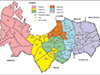
Location The 4th District is located in the north center of Pangasinan Province in the Ilocos Region (Region I) of northern Luzon in the Philippines. Borders Lingayen Gulf to the northwest and the provincial border with La Union Province to the north, 5th District to the east and 3rd District to the south. Dagupan Lat 16° 6' 0N Long 120° 31' 0E Dagupan is located between Lingayen and San Fabian. General MacArthur landed at Bonuan (Blue Beach) on the coast of Dagupan December 12, 1945 three days after the initial American landing, to officially return to Luzon and made his HQ at the West Central Elementary School in the center of Dagupan. Mangaldan Borders Lingayen Gulf to the north and Dagupan to the east includes Mangaldan Airfield (Honey). San Fabian Lat 16° 7' 42N Long 120° 24' 39E Coastal town on the NE side of Lingayen Gulf. Site of American liberation landing by I Corps. The Catholic Church was damaged by bombardment and the town became a major staging area for movement inland. Angio Barangay of San Fabian San Jacinto San Jacinto located to the southeast of San Fabian. Manaoag Manaoag located at the southeast of the 4th district. Sometimes mispelled Manoag in American wartime sources. Contribute
Information Last Updated
|
Map Province Map Fallingrain Map Mapcarta |
| Discussion Forum | Daily Updates | Reviews | Museums | Interviews & Oral Histories |
|