|
|
|
|
| Missing In Action (MIA) | Prisoners Of War (POW) | Unexploded Ordnance (UXO) |
| Chronology | Locations | Aircraft | Ships | Submit Info | How You Can Help | Donate |
|
 38th BG circa 1943  38th BG January 8, 1944  AWM May 21, 1944  Justin Taylan Sept 2003 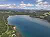 Justin Taylan May 2025 |
Location Lat 4° 30' 0S Long 145° 25' 0E Ulingan Harbor is located on the north coast of New Guinea. Allied wartime spellings include Ulingan, Uligan and Ulingen. Borders Ulingan (Uligan, Ulingen) to the west and beyond to the east is Meiwok. The mouth of Uligan Harbor at the northern end connects into the Bismarck Sea. Between 1884 until September 1914 part of Deutsch Neu Guinea (German New Guinea). Prewar and during the Pacific War located in Madang District in the Territory of New Guinea. Today located in Bogia District, Madang Province in Papua New Guinea (PNG). Wartime History In January 1943 Ulingan Harbor was occupied by the Japanese Army causing the local population to flee inland. Ulingan village was developed into a depot area with anti-aircraft guns emplaced to defend the area. During 1943 until early 1944, the Japanese used the North Coast Road northward from Hansa Bay via Uligan then southward to Madang for transporting supplies. Also, Uligan Harbor was used by Japanese barges moving along the north coast or as a location to hide them during daylight hours. During 1943 until early 1944, the Japanese used the North Coast Road via Uligan northward from Hansa Bay and southward to Madang for transporting supplies. Also, Uligan Harbor was used by Japanese barges moving along the north coast or as a location to hide them during daylight hours. Starting in early April 1943 until late May 1944 the Ulingan area was the target of Allied aerial attacks and shore bombardments by naval vessels. Between January 1944 to March 1944, several Allied planes crashed in the vicinity. Allied mission against Ulingan Harbor April 10, 1943–May 21, 1944 During late May 1944, the Ulingan area was liberated by Australian Army soldiers. On June 24, 1944 while in Uligan Harbor, HMAS Bundaberg (J231) recovered a 37mm Anti-Tank Gun from a sunken Japanese barge as a war prize for the citizens of Bundaberg. Today Ulingan remains a small village. The adjacent bay is popular for surfing developed by the Surfing Association of Papua New Guinea (SAPNG) and the Tupira Surf Club. Japanese Shipwreck Submerged Japanese wooden ship that is burned and sunk near the mouth of Ulingan Harbor. P-39Q Airacobra Serial Number 42-20355 Pilot Diffenderffer crashed April 9, 1944 two miles out to sea, 1 missing References At Close Quarters (1962) pages 238 (April 10, 1944 bombardment of Ulingen Harbor) Pub. 164 Sailing Direction (Enroute) (1994) pages 218-219, 277 (index Ulingen Harbor) Pages 218-219 "Ulingen Harbor, entered about 2 miles W of Neptune Point, is a narrow inlet, indenting the coast for about 0.5 mile; it is enclosed by wooded hills on the S and E sides, and partly on the W. A reef extends about 0.2 mile from the E entrance point of the harbor. Anchorage may be obtained, in 29 to 37m, N of the above reef, by vessels up to 1,000 tons, with local knowledge. 9.89 Ulingen Harbor was reported to give a good radar return at a distance of 10 miles." Contribute
Information Last Updated
|
Map Fallingrain Map Mapcarta Map 2013 Photo Archive View on Google Earth |
| Discussion Forum | Daily Updates | Reviews | Museums | Interviews & Oral Histories |
|