|
|
|
|
| Missing In Action (MIA) | Prisoners Of War (POW) | Unexploded Ordnance (UXO) |
| Chronology | Locations | Aircraft | Ships | Submit Info | How You Can Help | Donate |
|
 USN August 18, 1942 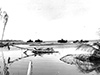 USMC October 24, 1942 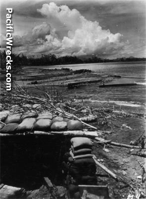 US Army January 8, 1943  US Army January 17, 1943 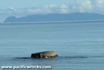 Peter Flahavin 2004  Justin Taylan 2006 |
Location Lat 9° 25' 60S Long 159° 58' 0E Matanikau village is located at the mouth of the Matanikau River (Mataniko River) on the north coast of Guadalcanal. Also spelled Matanikao. Prewar and during the Pacific War part of the British Solomon Islands Protectorate (BSIP). Today, located in Honiara in Guadalcanal Province the Solomon Islands. Matanikau has expanded southward and includes the "Chinatown" area to the south. Prewar A small village was located to the west of the mouth of the Matanikau River with roughly twenty-five huts made of bush materials with a population of locals who tended gardens and fished offshore. Wartime History In early July 1942 occupied by the Japanese Army. After the U.S. landing on August 7, 1942, the U.S. Marines advanced to the eastern side of the Matanikau River. During the early months of the Battle of Guadalcanal the river formed the western edge of the U.S. perimeter on Guadalcanal with the Japanese Army occupying the west side of the river and launched several offensives eastward against the American lines. Matanikau River The Matanikau River runs roughly south to north with the mouth to the east of Matanikau on the north coast of Guadalcanal. During the battle of Guadalcanal, the Matanikau River formed the western edge of the U.S. perimeter during the first months of the battle. On August 12, 1942 a U.S. Marine Corps (USMC) patrol led by Colonel Frank B. Goettge dubbed the "Goettge Patrol" accompanied by a Japanese Prisoner Of War (POW) crossed the Matanikau River to the western bank in hopes of accepting the surrender of Japanese forces the prisoner claimed were willing to surrender. Instead, the patrol was ambushed. Before dawn, the entire patrol had been wiped out aside from three survivors who managed to swim back to friendly lines one at a time. On August 27, 1942 at 6:10am U.S. Marines from I/3/5 advanced along the Government Track while 75mm and 105mm artillery fire from the 11th Marines shelled the mouth of the Matanikau River. The Marines killed two stragglers and crossed the river without opposition then advanced between Hill 78 and the coast. At 4:00pm they met strong opposition from Japanese machine gun fire and rifles at the base of Point Cruz. Unable to flank the enemy, Col. William Whaling arrived to take command but they were unable to advance and instead withdrew 100 yards and dug in overnight. On August 28, 1942 before dawn I/3/5 with 1/5 advanced and found the enemy had withdrawn overnight. After patroling as far as Rove Creek, the Marines turned back to the east and when they returned to Matanikau village, burned the remaining huts to destroy what remained then withdrew aboard Higgins boats back to Kukum. Matanikau Sandbar The Matanikau Sandbar was located to the east of the mouth of the Matanikau River. On October 24, 1942 seven Japanese Army Type 97 Chi-Ha medium tanks from the 1st Independent Tank Regiment advanced eastward and were disabled by the Marines. Afterwards, the six tank hulls were demolished by the Marines to prevent them from being used as defensive positions by the Japanese. The seventh Type 97 Chi-Ha medium tank was partially submerged and remains in situ. The remains of the other tanks were buried in the sand or otherwise disappeared since the war. Type 97 Chi-Ha Medium Tank Disabled October 24, 1942 remains in situ partially submerged near the mouth of the Matanikau River. Hill 73 (American Memorial, Skyline Ridge) Hill near Matanikau River. During the night of August 18-19, 1942 the Marines bivouac on this hill for the night. and were attacked at dawn by the Japanese. Today, it is the site of the main American memorial on Guadalcanal. Matanikau Falls (Mataniko Falls) Two hours by foot from Honiara on Guadalcanal is the spectacular double-sided Mataniko Falls. The falls thunder into a cave full of stalagmites and swooping swallows and bats. During WWII, the cave was a hide-out for Japanese soldiers trying to avoid capture by the Americans. Start out on the 1.5 mile road from Chinatown to Tuvaruhu. Cross the river at Tuvaruhu, and proceed along the top of the ridge. The trail is often steep, and you might do better with a guide after Tuvaruhu. References The Village (2008) by John Innes Guadalcanal's Longest Fight: The Pivotal Battles of the Matanikau Front (2025) pages 34 (map), 43 (August 28, 1942 burning Matanikau village), 235 (index Hill 73) Contribute
Information Last Updated
|
Map Fallingrain Map Mapcarta |
| Discussion Forum | Daily Updates | Reviews | Museums | Interviews & Oral Histories |
|