|
|
|
|
| Missing In Action (MIA) | Prisoners Of War (POW) | Unexploded Ordnance (UXO) |
| Chronology | Locations | Aircraft | Ships | Submit Info | How You Can Help | Donate |
|
 USN August 18, 1942 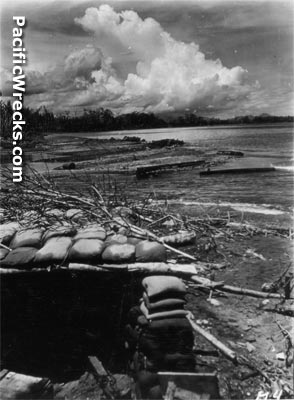 US Army January 8, 1943 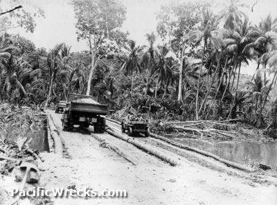 US Army January 17, 1943 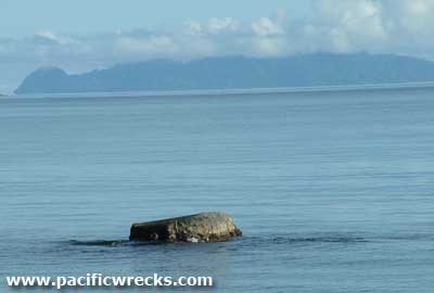 Peter Flahavin 2004 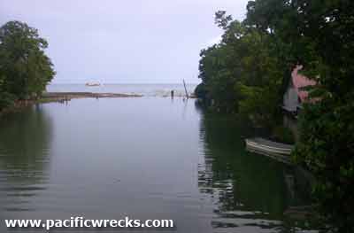 John Innes 2005  Justin Taylan 2006 |
Location The Matanikau River runs roughly south to north with the mouth to the east of Matanikau (Mataniko) on the north coast of Guadalcanal. Prewar and during the Pacific War there was no bridge spanning the river and was part of the British Solomon Islands Protectorate (BSIP). During the battle of Guadalcanal, th the Matanikau River formed the western edge of the U.S. perimeter on Guadalcanal. Postwar, the "Chinatown Bridge" spans the Matanikau River. Today, located in Honiara in Guadalcanal Province the Solomon Islands. Wartime History In early July 1942 occupied by the Japanese Army. After the U.S. landing on August 7, 1942, the U.S. Marines advanced to the eastern side of the Matanikau River. During the early months of the Battle of Guadalcanal the river formed the western edge of the U.S. perimeter on Guadalcanal with the Japanese Army occupying the west side of the river and launched several offensives eastward against the American lines. On October 23, 1942 in the evening, the Japanese Army begins an offensive along the Matanikau River against the U.S. perimeter with artillery fire followed by an assault by an infantry regiment supported by tanks. Defending, the eastern side of the river is the U.S. Marine Corps (USMC) 3rd Battalion, 1st Marines. By October 24, 1942 in the early morning, the Japanese assault had failed and tanks attempted to cross the sandbar at the mouth of the river and were all disabled by gunfire and abandoned. On October 31, 1942 during the night, E Company, 5th Marines crosses the Matanikau River and establishes outposts on the west bank. Meanwhile, 1st Engineer Battalion rushes to build three footbridges across the river that are in place by November 1, 1942. Later, these bridge are expanded and improved. By early 1943, a one lane bridge for vehicles was built inland from the mouth of the river. Matanikau Sandbar The Matanikau Sandbar was located to the east of the mouth of the Matanikau River. On October 24, 1942 seven Japanese Army Type 97 Chi-Ha medium tanks from the 1st Independent Tank Regiment advanced eastward and were disabled by the Marines. Afterwards, the six tank hulls were demolished by the Marines to prevent them from being used as defensive positions by the Japanese. The seventh Type 97 Chi-Ha medium tank was partially submerged and remains in situ. The remains of the other tanks were buried in the sand or otherwise disappeared since the war. Type 97 Chi-Ha Disabled October 24, 1942 remains in situ partially submerged near the mouth of the Matanikau River. Matanikau Falls (Mataniko Falls) The Matanikau Falls (Mataniko Falls) is a double-sided waterfall inland from the north coast. The water fall empties into a large cave full of stalagmites, swallows and bats. During the later stages of the Guadalcanal campaign, this cave was used as a hideout by Japanese soldiers trying to avoid capture. The falls are roughly a two hour hike from from Chinatown starting at the 1.5 mile road to Tuvaruhu where you cross the river and can hire a guide to walk along the top of a ridge that is often steep that leads to the waterfall. References The Village (2008) by John Innes Guadalcanal's Longest Fight: The Pivotal Battles of the Matanikau Front (2025) pages 34 (map), 235 (index Hill 73) Contribute
Information Last Updated
|
September 27, 1942 Map Fallingrain Map Mapcarta |
| Discussion Forum | Daily Updates | Reviews | Museums | Interviews & Oral Histories |
|