 |
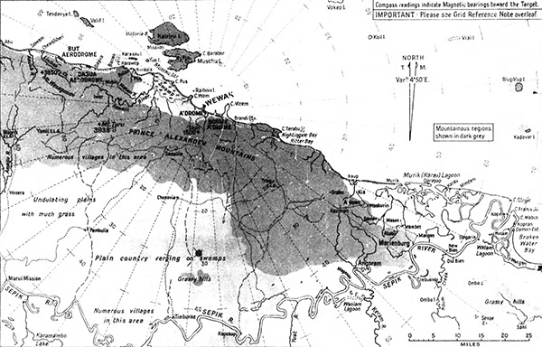
Map of the north coast of New Guinea
The map includes the north coast of New Guinea including But Airfield, Dagua, Dagua Airfield, Banak, Boiken (Boikin), Hawain River, Cape Pus (C. Pus), Cape Wom (C. Wom), Wewak (Wewak Town), Wewak Airfield (A'Drome), Sauri, Boram Airfield and Cape Moem (C. Moem), Brandi Plantation (Brandi Ptn), Cape Terabu (C. Terabu), Nightingale Bay (Makabing Bay), Ritter Bay, Kaup, Murik, Murik Lakes (Murik Lagoon). Inland is the Prince Alexander Mountains. Offshore is Muschu Strait (Muschu Passage), Raiboin Island (Raboin Island), Muschu Island and Kairiu Island and Wallis
Island (Valif Island). Interior locations linclude Maprik (Kominibus), Maprik Airfield (Maprik E.L.G., Hayfield Airfield), Amagu River, Wosera, Yamil, Yami Airfield (Yamil E.L.G.) with numberous villages in this area. walking trails (dotted lines) and Mount Turu (Mt. Turu) elevation 3,938' and the Hawain River. In the lower portion of the map is the Sepik River bordering Watam, Watam Lagoon, Kopa, Singarin, New Bien, Old Bien, Marienburg (Marienberg), Angoram (Angorum) and Timbunke. The Sepik River connects to Koum Creek, Keran River, Yuat River and Karamambo Lake. At the center is a black dot above "plain country verging on swamps" and "gassy hills" with walking trails (dotted lines) indicating the approximate location where B-25G 42-64835 force landed to the north of the Sepik River and Timbunke.
Credit: MACR 3981 page 2 Date: August 30, 1943
Digital
High Resolution Version
Acquire This Image |
Contribute Information
Do you have photos or additional information?
Previous Page
|
|