|
|
|
|
| Missing In Action (MIA) | Prisoners Of War (POW) | Unexploded Ordnance (UXO) |
| Chronology | Locations | Aircraft | Ships | Submit Info | How You Can Help | Donate |
|
 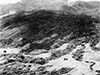 USMC 1942 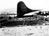 RNZAF 1943 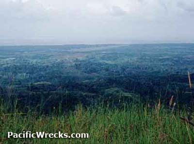 Peter Flahavin 1995 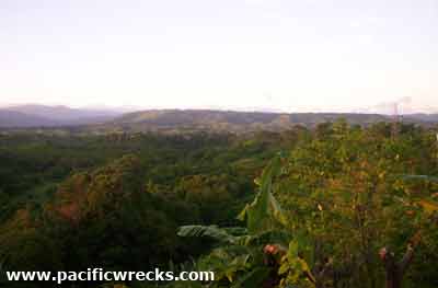 John Innes 2005  Justin Taylan 2006 |
Location Lat 9° 28' 60S Long 159° 58' 60E Mount Austen has an elevation of 1,514' on northern Guadalcanal. Also known as Mt. Austen. The local people call the feature "Mombula" or "Mambula" meaning rotting body in the Guadalcanal language. During the Guadalcanal campaign known as "Grassy Knoll" to the Americans. To the west is The Gifu, Sea Horse (Seahorse) and Galloping Horse. The view across the northern coast of Guadalcanal are magnificent including views of Honiara, Henderson Field and the Lunga Point. Prewar and during the Pacific War part of the British Solomon Islands. Today part of Guadalcanal Province in the Solomon Islands. Since the 1990s, a surfaced road goes to the summit of Mt. Austen, over top the original "East-West Trail". Wartime History On August 7, 1942 U.S. Marines (USMC) were tasked with the objective of occupying the "Grassy Knoll" (Mount Austen) but moving inland, they became lost in the jungle and were unable to reach their objective due to poor maps and intelligence about the island. Invasion planners did not realize the mountain was far inland. The prewar East-West Trail spanned the northern edge of the mountain. Japanese Observation Post at the summit of Mount Austen During the night of September 21, 1942 to September 22, 1942 Imperial Japanese Navy observer, Lt. Commander Kenji Mitsui established an observation post near the summit of Mt. Austen where he operated a radio. From this location, he was able to observe and report on American forces inside the perimeter area, aircraft at Henderson Field and shipping off Lunga Point. This observation post was likely camouflaged with netting and not visible from above by aerial observation. He remained at this position until early December 1942. According to Mitsui, his position was compromised when an American artillery shell was fired at his position forcing him to abandon it. He was later evacuated by submarine in January 1943. On October 7, 1942 a patrol of eight Marines from G-2-1 were the first patrol to reach the Grassy Knoll (Mount Austen) to observe the Marine offensive on the Matanikau River. While atop Mt. Austin, the patrol's radio operator Sam Philps experienced radio interference from a nearby transmitter, likely from the Japanese observation post. A few minutes later, their patrol came under attack and withdrew. On December 2, 1942 Marine Raiders led by Col. Carlson during his "Long Trek Patrol" patrol crossed the Lunga River, got a report that the summit was unoccupied and got permission to explore the southernmost east-west trail. On December 3, 1942 they encountered Japanese positions at the summit and suffered four casualties: Jack Miller, was WIA in the chest by a fire from a captured Thompson submachine gun and was carried out, but died the next day. Killed during the patrol were: Cpl Albert L. Hermiston, 276542 (KIA, BNR, MIA), Richard C. Farrar (KIA, BR) and Cyrill A. Matelski, Glenn Mitchell. Seriously wounded and later died were Lt. Jack Miller and Pvt Stuveysant Van Buren. All three were buried near the summit. During 1947, their remains were recovered by AGRS. Carlson's raiders inflicted at least eight Japanese casualties. They observed a trail leading inland towards The Gifu (Barana) before withdrawing towards the Matanikau River. Afterwards, the Mt Austen was part of the USMC west sector controlled by Col John M. Arthur until December 8, 1942 when the U.S. Army took over offensive operations on Guadalcanal. On December 15, 1942 General Patch orders the 132nd Infantry Regiment, Americal Divison to occupy Mount Austen. During December 1942 the U.S. Army began the Battle of Mount Austen. By December 17-18, 1942 the remaining Japanese atop Mount Austen withdrew from the summit towards The Gifu (Barana). Between December 29-31, 1942 soldiers from the U.S. Army 164th Infantry Regiment, 1st Battalion patrolled Mount Austen and observed eight dead Japanese and positions atop the summit, plus the field burials of three Marines. The patrol made a more accurate map of the summit area. On January 1, 1943 the 132nd Infantry Regiment, 2nd Battalion made a flanking attack towards Mount Austen and captures Hill 27. Afterwards, Mount Austen was within the American lines. Sea Horse January 8-11, 1943 battle area on Guadalcanal located to the west of "The Gifu". Galloping Horse January 10-13, 1943 battle area on Guadalcanal with Sims Ridge and Exton Ridge. The Gifu Strong point near Mount Austen between Hills 31 and Hill 27), named for Gifu Prefecture, the hometown of most of the defenders. U.S. Memorial Pillar on Mount Austen Plaque missing since late 1990s References Patrol of 1st Bn. 164th Infantry -- December 29, 30 and 31st. 1942 page 1-2, map 104 overlays Real Blood! Real Guts! U.S. Marine Raiders and their Corpsmen in WWII by James Gleason, page 115-116 FindAGrave - Richard C Farrar buried Kinsey Cemetery in Poplar Bluff, Missouri FindAGrave - Cyrill Anthony Matelski buried National Memorial Cemetery of the Pacific (Punchbowl) C, 1384 FindAGrave - Glenn L Mitchell buried Golden Gate National Cemetery section D, site 184 date of death incorrect Guadalcanal's Longest Fight: The Pivotal Battles of the Matanikau Front (2025) pages 34 (map), 235 (index Hill 73) Thanks to John Innes and Peter Flahavin for additional information Contribute
Information Last Updated
|
Map Aug 1942 Photo Archive |
| Discussion Forum | Daily Updates | Reviews | Museums | Interviews & Oral Histories |
|