|
|
|
|
| Missing In Action (MIA) | Prisoners Of War (POW) | Unexploded Ordnance (UXO) |
| Chronology | Locations | Aircraft | Ships | Submit Info | How You Can Help | Donate |
|
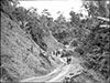 AWM April 8, 1944 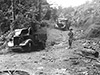 AWM April 9, 1944  AWM April 10, 1944 |
Location The Bogadjim Road was built by the Japanese Army starting at Bogadjim on the north coast of New Guinea then inaland to the southwest to Yaula in the Finisterre Range. Also known as the "Bogadjim-Yaula Road" or "Bogadjim-Ramu Road". Prewar and during the Pacific War located in the Territory of New Guinea. Today located in Madang Province in Papua New Guinea (PNG). Prewar The Bogadjim-Yaula Track, a native native walking trail spanned from Bogadjim inland to Yaula then connected to other trails across the across the Finisterre Range. Construction By late February 1943 the Japanese Army had surveyed prewar roads and walking tracks from the north coast for development into a military road that would span from the north coast across the Finisterre Range to the Ramu Valley then onward to Lae with a completion date scheduled for December 22, 1943. The road would require two major bridges and 123 culverts made of logs plus substantial earthmoving. If completed, this route would provide a safer route for supplies versus using Japanese ships or barges that were subjected to Allied attacks. The Japanese planned to expand the Bogadjim-Yaula Track from Bogadjim to Yaula then a trail southward via Daumoina to Yokopi. From there, the Japanese planned another 48 miles of road into the Ramu Valley to Sanewas near Wampun then onward to Lae. For six months, the Japanese Army labored to build this inland road known as the Bogadjim Road or Bogadjim-Yaula Road. The labor force include the Japanese Army 20th Division plus 880 personnel from the 4th Engineering Group augmented by Korean laborers and locals. The force was augmented by soldiers from the 79th Infantry Regiment and 80th Infantry Regiment plus the attached 20th Engineering Regiment then departing for Finschafen. Construction began in late February 1943 and the first portion of the inland road extended to Bauak by April 3, 1943 and then expanded to Kwato / Yaula by April 10, 1943. From there, construction slowed due to difficult terrain and weather. By September 10, 1943 the road reached Yokopi. This segment of the road was inspected by Lt. General Kane Yoshihara, Chief of Staff, 18th Army who stated: "I inspected the construction of this highway [Bogadjim Road] and it was a fine road crossing the left bank mountain stream and cutting off the right bank precipice, going from this side of the Bogadjim valley to the other side." After the Allied landed at Lae, the Japanese had managed to complete a segment of road from Bogadjim to Yaula a major engineering feat, despite bad weather, flooding and limited supplies. The road from Erima to Yaula spanned 29 kilometers over 45 bridges built from logs. Wartime History By early April 1943 the road from Bogadjim was used to move supplies using a fleet of twenty trucks from the coast inland to Yaula. Beyond, roughly 300 horses were used as pack animal with half working the route while the other half rested at Madang then were swapped. During July 1943, a New Guinea native constable named Merire working for the Allies did a reconnaissance of the Japanese road project and reported his observations. Using this intelligence, on July 18, 1943 an F-5 Lightning performed a photo reconnaissance of the area from Bogadjim to Yaula. Reviewing the photographs, General Whitehead wrote to General Kenney "The size and scope of this construction project amazed all of us... the target appears lucrative." On July 20, 1943 a large bombing mission by B-25 targeted the area including supply dumps and three bridges on the Madang to Bogadjim section of the road. On July 21, 1943 the same B-25s hit Bogadjim and road construction targets and killed over a hundered Japanese on the ground. American missions against Bogadjim Road June 1, 1943 - April 2, 1944 By August 1943, the Bogadjim Road was targeted by Allied bombers and fighters that targeted bridges and the road. To counteract the aerial attacks, the Japanese moved supplies at night and if a bridge was destroyed used manpower to move cargo from one side of a river to the other until the supplies reached Yaula. During October 1943, the Australian Army, 2/6 Commando Squadron, B Troop under the command of Lt. Charlie Ball managed to patrol on the Solu River and patrolled up to the Bogadjim Road and reached Bogadjim. Facing difficult conditions and bad weather, by January 1944, all the horses had died from malnutrition or overwork. Afterwards, laborer carried 30kg loads by hand until early 1944 when construction ceased as the Australian Army troops neared the area. On April 9, 1944 the Australian Army 57/60th Infantry Battalion occupied Yaula and found at least two Japanese Army Isuzu TU10 6x4 trucks were captured at this location plus other logistical materials including wooden wheels and fuel drums. Today Disused since the Pacific War, the former road has reverted to a walking trail used by locals. References Monograph No. 38 "Map of Construction of Madang-Lae Road Feb-Sept 1943" page 164 Richard Dunn adds: "This indicates HQ 20th Div and various attached units had arrived in Erima by late February 1943. Attached units in addition to 20th Eng Rgt included two indep Eng Regts, three coys of a Road Cons Bn and a transportation Regt. Indicates a motor road was completed Erima to Bauak by 3 April and Kwato or Yaula by 10 April. Then progress slowed. Yokopi was reached 10 Sep, still a long way from Ramu River. Meanwhile a pack horse route was blazed from Mabalugu from 10 July reaching Dumpu by end of July. Japanese considered Aussie forces operating from Bena Bena a threat to this road construction. They began raids on targets in Bena Bena area beginning in May." On Shaggy Ridge (2004) by Phil Bradley pages 56, 119, 163-166, 169, 172, 259 (footnote 23, 24, 25 - New Guinea Force Advanced HQ AW52 1/2/2 January 1944, page 43, 92 - Southern Cross AWM 54 423/4/154 page 80), 274 (index) Hell's Battlefield (2012) by Phil Bradley pages 300 (map), 302 (footnote 8), 457 (footnote 8, AWM52 1/2/2/009, 092) 485 (index) D-Day New Guinea (2019) by Phil Bradley "Further west in the Ramu Valley the Japanese were also contesting the presence of the Australians. Much of the increased activity was related to the military road which was being constructed from Bogadjim on the north coast up the valley of the Mindjim River to Yaula and Yokopi with the intention of crossing the Finisterre Range into the Ramu Valley. The stretch from Erima to Yaula was 29 kilometres long and required 45 bridges to be built. After that it was still another 25 kilometres to Yokopi. On 6 June the astute General Kenney wrote, ‘I don’t think he will ever finish it. If he does, air attack will keep him from using it.’" "Good use was made of this intelligence. On 18 July an F-5 Lightning photo-reconnaissance aircraft took excellent photos of the road from Bogadjim to Yaula. ‘The size and scope of this construction project amazed all of us . . . the target appears lucrative,’ General Whitehead wrote in a report to General Kenney. On 20 July three medium-bomber squadrons, taking part in the deepest penetration by attack bombers into enemy territory to date, attacked supply dumps and three bridges on the Madang to Bogadjim section of the road. The next day the medium-bomber squadrons were back in a major air attack on the road itself. ‘At noon their airplanes strafed and bombed us with terrific firepower,’ one Japanese officer wrote. The raid killed 114 Japanese officers and men." Thanks to Lawrence Awak for tok ples spellings of Bugadim and Phil Bradley and Richard Dunn for additional information. Contribute
Information Last Updated
|
Map 1944 Map Google Earth Photo Archive |
| Discussion Forum | Daily Updates | Reviews | Museums | Interviews & Oral Histories |
|