|
|
|
| Missing In Action (MIA) | Prisoners Of War (POW) | Unexploded Ordnance (UXO) |
| Chronology | Locations | Aircraft | Ships | Submit Info | How You Can Help | Donate |
|
  RAN c1915 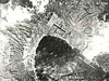 RAAF February 14, 1942 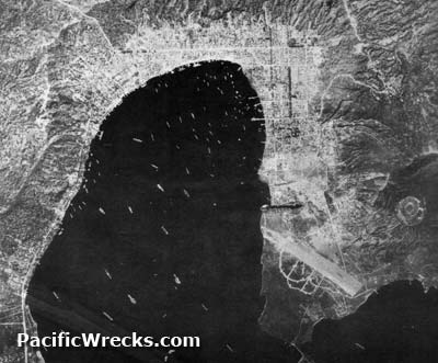 USAAF June 17, 1943 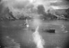 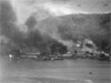 USAAF Nov 2, 1943 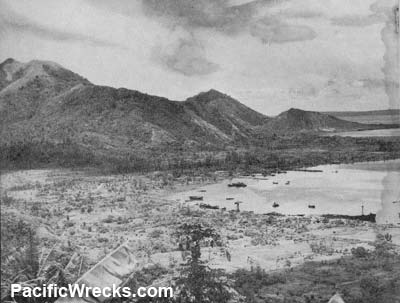  RNZAF September 1945 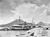 RAN October 5, 1945 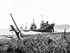 RAN October 25, 1945 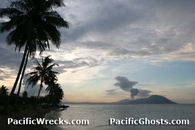 Justin Taylan 2005 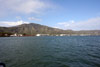 Yoji Sakaida 2007 |
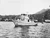
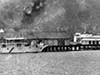
Location Simpson Harbor is the flooded caldera of an ancient volcano of the Gazelle Peninsula that forms the eastern tip New Britain. Borders Rabaul to the north and Sulphur Creek to the northeast and Matupit Island at the southeast. Toboi Wharf, Komaki Maru (Wreck Wharf) and others smaller docks and wharfs provide access and Rabaul. Inside Simpson Harbor to the west are the Dawapia Rocks (The Beehives). Simpson Harbor borders Karavia Bay to the south and Blanche Bay to the southeast. Between 1884 until September 1914 part of Deutsch Neu Guinea (German New Guinea). Prewar and during the Pacific War part of the New Britain District in the Territory of New Guinea. During the 1960s, East New Britain Province was created by the Australian Administration. Today located in Papua New Guinea (PNG). Prewar During the German colonial era, a long wooden wharf was built on the eastern shore of Simpson Harbor north of Sulphur Creek near the present day Rabaul Yacht Club (RYC). World War I In the middle of September 1914, the Australian Naval and Military Expeditionary Force (AN&MEF) arrived in Simpson Harbor to occupy and administer the German colony. World War II On January 23, 1942 after midnight, the Japanese Army 144th Infantry Regiment "South Seas Detachment" landed at several locations around Rabaul including Raluana Point and to the west of Kokopo and Kerawun and north of Vulcan. Also Malaguna, west of Praed Point and Nordup. By morning, Japanese forces occupied Rabaul. Immediately, the Japanese developed Simpson Harbor into their principal anchorage in the South Pacific, and used Simpson Harbor as a seaplane operating area with servicing areas at Sulpher Creek and Matupit Island. During the Pacific War, Rabaul and Simpson Harbor were subjected to Allied aerial attacks that began in February 1942. Allied missions included day and night high altitude bombing raids, medium bombing raids and low level strikes against shipping and aerial mining missions. Allied bombing missions continued until the official surrender of Japan in September 1945. Allied missions against Simpson Harbor February 3, 1942–1945 On February 19, 1944 the last Japanese ship to enter Simpson Harbor was the Kokai Maru that unloaded barges, ammunition and food, then departed on February 25, 1944. Afterwards, only submarines managed to deliver small quantities of essential cargo to Rabaul. On September 6, 1945, the Japanese surrendered all remaining Japanese Forces in New Guinea, New Britain and the Solomon Islands. The ceremony took place aboard HMS Glory (R62). Representing the Japanese was Japanese Army (IJA) General Hitoshi Imamura, Commander 8th Army Area and Imperial Japanese Navy (IJN) Vice Admiral Jinichi Kusaka, Commander South East Area Fleet. Postwar On October 22, 1956 Japanese salvage companies Okadigumi Salvage Co. and Nayo Boeki Kaisha were given permission to salvage shipwrecks around Rabaul. During 1957-1958 salvaging shipwrecks including Naruto (Japanese Tanker No. 5301) that was loaded with scrap metal and then towed to Singapore and scrapped. Today Reportedly 54 ships were sunk into Simpson Harbor and the surrounding area, but only 10 are accessible or known to SCUBA divers. At least two former submersible barges abandoned after the war survived, and were used as tankers around East New Britain and Duke of York Islands well into the 1990s. But, they remained strictly on the surface after the war, by expatriate Pat Roberts who ran an inter-island shipping business from Rabaul. Brian Bennett recalls: "Pat Roberts (his place was known just as Pat's wharf and is situated at the end of Dawapia Road. Also known as Rabaul Shipping. Pat and his wife from Buka are long gone now. After the war a chap named Pat Roberts who ran a fuel and fresh water provider business for many years for visiting ships acquired several of these vessels and at least one was still in use at the time of the eruption in 1994. Pat also did metal salvage and his place was always a delight to search for old brass fuse and stuff. I remember that after he died his house became a bit run down and out in the front yard he had the glass reflector dish out of the biggest of the Japanese Naval search lights." Don Robinson adds: "From 1952 to 1962, I operated a transport in Rabaul and transported all of the scrap out of Rabaul, including hundreds of Japanese planes cut up for scrap. They were sold back to Japan to make cars. It was so common, I took no photos." Toboi Wharf Prewar wharf located at the northwest corner of Simpson Harbor. German Wharf During the German Administration, a long wooden wharf was built on the eastern shore of Simpson Harbor north of Sulphur Creek near the present day Rabaul Yacht Club (RYC). After Australian occupation of German New Guinea it became known as the "German wharf" or "main wharf" and remained in use until it was destroyed by Allied bombing during World War II. Dawapia Rocks "The Beehives" Pair of volcanic rock outcroppings in Simpson Harbor, that look like a pair of beehives. Located in roughly the center of the harbor, west of Matupi Island and east of Malaguna. Komaki Maru (Wreck Wharf) First Japanese ship confirmed sunk by Allied aircraft in Simpson Harbor Hakkai Maru Sunk by B-25s on January 17, 1943. Covered by the 1994 volcano eruption Kanshin Maru Sunk on January 17, 1944 covered by the 1994 volcano eruption Kisargel Maru Partially sunk into Simpson Harbor at the end of the Pacific War, salvaged or scrapped postwar Manko Maru Sunk near the present day wharf area Italy Maru Largest ship sunk in Simpson Harbor Suzunami Sunk on November 11, 1943 during air attack and exploded while loading torpedoes Yamamoto Maru Sunk April 18, 1943 P-39Q Airacobra Serial Number 44-2451 Pilot Bodge crashed March 12, 1944 wreckage located October 1986 TBF-1 Avenger Bureau Number 24264 Pilot Boyden crashed February 14, 1944 near the Rabaul Yacht Club SBD-5 Dauntless Bureau Number 36913 Pilot Alford MIA June 16, 1944 Oogata Unkato No. 1 (Large Type Cargo Transporting Tube) Japanese submersible fuel barges survived the war and was in use until the early 1980s References AWM Salvage of Japanese ships in Simpson Harbour, Rabaul F07356 Contribute
Information Last Updated
|
Photo Archive |
| Discussion Forum | Daily Updates | Reviews | Museums | Interviews & Oral Histories |
|