|
|
|
|
| Missing In Action (MIA) | Prisoners Of War (POW) | Unexploded Ordnance (UXO) |
| Chronology | Locations | Aircraft | Ships | Submit Info | How You Can Help | Donate |
|
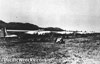 USAAF Sept 9, 1941  Robinson June 1, 1942  Damien Parer August 1942 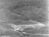 USAAF Dec 8, 1942 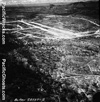  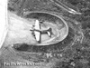 43rd BG c1943 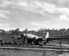 43rd BG c1943 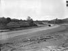 USAAF February 1943 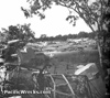 USAAF June 1945  338th RS October 17, 1947  Albert Cross 1962 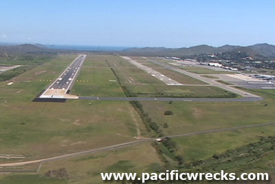 Justin Taylan 2003  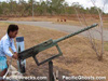 Justin Taylan 2005  Justin Taylan 2006 |
Location Lat 9° 26' 36S Long 147° 13' 12E 7 Mile Drome is located roughly seven miles to the northeast of Port Moresby inland from the southern coast of New Guinea. Prewar and during the Pacific War located in the Territory of Papua. Still in use today as Jackson Airport. Also known as Port Moresby Jacksons International Airport or Port Moresby International (Jacksons) in the National Capital District (NCD) of Papua New Guinea (PNG). During World War II, known to the Allies as 7 Mile or 7 Mile Drone or 7-Mile because it was roughly seven miles north of north of Port Moresby. The Japanese code named the airfield RZR. On November 10, 1942, renamed "Jackson Drome" in honor of Royal Australian Air Force (RAAF) Squadron Leader John F. Jackson. Postwar, known as "Jackson Airport". Today officially known as "Port Moresby Jacksons International Airport" or "Port Moresby International (Jacksons)". Locally known as simply "Jacksons". Construction Built prewar with two parallel runways. On September 9, 1941 U.S. Army Air Force (USAAF) B-17 Flying Fortresses landed at 7 Mile Drome while en route to Clark Field in the Philippines. During the Pacific War, 7 Mile Drome was further expanded and improved by both the Australian and American personnel. Wartime History During the Pacific War, 7 Mile Drome became the primary airfield at Port Moresby used by civilian aircraft, Royal Australian Air Force (RAAF) and U.S. Army Air Force (USAAF) as a military airfield. On February 24, 1942 the first Japanese G4M1 Bettys bombed 7 Mile Drome destroying a parked Hudson A16-167 and a Gannet monoplane. During early 1942, no Allied fighters were based at 7 Mile and Japanese aircraft were able to bomb and strafe without fear of interception. Japanese air raids and missions against Port Moresby February 24, 1942–September 20, 1943 On March 21, 1942 the first four Royal Australian Air Force (RAAF) P-40E Kittyhawks from No. 75 Squadron arrived at 7 Mile Drome. Only two hours later, Wackett Cox intercept and shoot down G4M1 Betty pilot Kawai. Until May 1942, No. 75 Squadron defends Port Moresby conduct strikes against the Japanese on the north coast of New Guinea. By April 1942 when U.S. Army and U.S. Army Air Force personnel arrived, 7 Mile Drome was further expanded and developed into a major military airfield. Designated U.S. Army APO 929. Revetment were constructed to protect parked aircraft and defenses. A network of taxiways between 7-Mile Drome (Jackson) and 5 Mile Drome (Ward) made it possible to taxi between the two airfields. On October 21, 1942 torrential rains, ahead of the wet season washed out the shale base of 7 Mile Drome and several nearby roads and bridges. The rain damaged was not repaired until late in the month, forcing B-17s to temporarily operate from 17 Mile Drome. The airfield was expanded with three parallel runways, running roughly northwest to southeast. In the middle was the original runway, a fighter strip 3,000' x 100' surfaced with martson matting (as of December 9, 1942). To the northeast side was a new bomber strip 3,000' x 150' surfaced with marston matting (as of December 9, 1942) later expanded to 3,750'. On the southwest side was a crash strip 7,500' x 100' (as of December 9, 1942). Japanese air raids and missions against Port Moresby February 24, 1942–September 20, 1943 Allied units based at 7 Mile Drome (Jackson) Royal Australian Air Force (RAAF) units No. 75 Squadron (P-40E Kittyhawks) Garbutt arrives March 21, 1942–May 1942 U.S. Army Air Force (USAAF) units 43rd BG, HQ Mareeba arrives January 1943–December 10, 1943 departs Dobodura 43rd BG, 63rd BS (B-17) Mareeba arrives January 20, 1943–October 29, 1943 departs Dobodura 43rd BG, 64th BS (B-17) Mareeba arrives January 20, 1943–October 29, 1943 departs Dobodura 43rd BG, 65th BS (B-17) Mareeba arrives January 20, 1943–December 11, 1943 departs Dobodura 43rd BG, 403rd BS (B-24) Mareeba arrives May 11, 1943–December 13,1943 departs Dobodura 35th FG, 40th FS (P-39 / P-400) Antil Plains arrives June 2, 1942– July 30, 1942 departs Antil Plains 35th FG, 41st FS (P-39 / P-400) Bankstown arrives July 20, 1943–August 16, 1943 departs Tsili Tsili 8th Service Group (8th SrG) arrives July 30, 1942–1944 departs 348th FG, HQ USA arrives June 23, 1943–December 16, 1943 departs Finschafen 348th FG, 340th FS (P-47) USA arrives June 23, 1943–December 13, 1943 departs Finschafen Naming On November 10, 1942 renamed "Jackson Drome" in honor of Royal Australian Air Force (RAAF) Squadron Leader John F. Jackson shot down and killed in action April 28, 1942 flying P-40E Kittyhawk A29-8. Today Still in use today, known as "Jackson Airport" or "Port Moresby Jacksons International Airport" or "Port Moresby International (Jacksons)". This is Papua New Guinea's international airport, and the air hub for all flights in and out of the country and used by smaller regional airlines and helicopter companies. The airport has two runways at an elevation above sea level of 146'. The first runway is oriented 32R / 14L measures 9,022' x 148' surfaced with asphalt. The second runway is oriented 32L / 14R measures 6,777' x 148' surfaced with asphalt. Airport codes: ICAO: AYPY and IATA: POM. Jackson Wing Memorial In front of the old control tower and old terminal building on the southwestern end of the airport was a wing shaped memorial with a bronze plaque dedicated to Royal Australian Air Force (RAAF) Squadron Leader John F. Jackson Killed In Action (KIA) on April 28, 1942 piloting P-40E Kittyhawk A29-8. The bronze plaque reads: "Erected in the memory of Squadron Leader John Francis Jackson, D.F.C. 75 Squadron Royal Australian Air Force, killed in action 28th April, 1942 aged 34 for whom this airfield is named." During 2015 when the old control tower and terminal were demolished, the wing memorial was relocated to the employee parking lot at the eastern end of the airport. Squadron Leader John Jackson Commemorative Display Located inside the international departures terminal, the Squadron Leader John F. Jackson commemorative display was opened on April 24, 2017 by his daughter, Patricia Jackson and son, Arthur Jackson. The commemorative display includes a glass display case with wreckage from P-40E Kittyhawk A29-8 including both undercarriage legs and a bent .50 caliber machine gun. Also, photographs, artifacts and letters associated with Jackson and a timeline of his career with No. 75 Squadron defending Port Moresby. PNG Defense Force Memorial Located on the northeastern side of the airport outside the Papua New Guinea Defence Force (PNGDF) memorial made from the tail rudder of a C-47 Dakota. Nearby is a single .50 caliber machine gun on a metal mount. Revetments After the Japanese air raid on August 17, 1942 the U.S. Army began constructing revetments around 7 Mile Drome to protect parked aircraft. At the northwestern end of the airport are several revetments for B-17 Flying Fortress and B-24 Liberators remained. During 2014-2016, airport extension bulldozed several, leaving only a few revetments that remain in situ. Air Depot Hangers At this location are two Butler Hangers with concrete bases built by the U.S. Army near the bomber revetment area at 7 Mile Drone. In 1980, the undercarriage of a Ford Trimotor and G4M1 Betty wing wreckage were recovered from this area to the PNG Museum by Bruce Hoy. Today, all that remains is the concrete base inside the Moitaka Wildlife Preserve. C-47A Dakota Serial Number 42-24139 (DC-3 P2-ANN) Stored in the Papua New Guinea Defense Force (PNGDF) area. C-47B-20-DK Dakota 43-49849 (DC-3 "Jim Taylor" P2-ANQ) Displayed on a pole near the Air Niugini building. C-47B Dakota Serial Number 44-76545 (DC-3 P2-002) Displayed at the Airways Hotel as "Balus Bar". P-400 Airacobra Serial Number AP 347 Since 1984 displayed at South Pacific Aero Club during 2016 moved to National Museum and Art Gallery (NMAG). Tent City On the SE of Jackson is exactly as it was during the war, and is littered with wartime debris, of 55 gallon drums and rusted drop tanks. This area was abandoned in 1944, and today is covered by bush and shrubs. This area was known as 'tent city' were troops were billeted, huts and mess halls constructed for the pilots and ground crews. When the kunai grass is burned off, there are some bits of aluminum and other wartime relics visible, including metal and drums. Enlisted Men's Club Behind Jackson, on top of a small hill, is the slab for the 65th Enlisted Men's Club. Portion of concrete engraved with this has been up-turned. In the valley below, away from the strip is the slab for the 64th Enlisted Men's club. Thanks to Bruce Hoy for this information. 65th Enlisted Men's Club Concrete Slab A concrete slab for the 65th Enlisted Men's Club is reported to still remains, in pieces, behind Jackson. Thanks to Bruce Hoy for this information. Fort Nub (John's Gully) Located to the north-west of 7-Mile Drome. In or near a feature know as John's Gully. The wartime road from 7-Mile northward, towards Sogeri, Owen's Corner and the start of the Kokoda Trail ran past this location. A wartime quarry was present to the west. Fort Nub was a base that was the nerve center for forward spotters, before they moved to Rouna. Warnings would be received at Fort Nub and relayed around the Port Moresby area to alert gun crews and sound alarms. The base was manned by Americans, and Australian were camped across the road. Ft Nub was the HQ for the 101st Light Anti-Aircraft unit from Georgia. The was a Australian Battalion there also that was responsible for coastal patrols around Port Moresby shoreline on a 24 hour basis. References NAC - Port Moresby International Airport (Jacksons) Engineer Aviation Units in the Southwest Pacific Theater during WWII by Natalie M. Pearson, 2005 [PDF] pp 45-46 Contribute
Information Last Updated
|
December 9, 1942 Map 1943 Map Fallingrain Photo Archive View in Google Earth |
| Discussion Forum | Daily Updates | Reviews | Museums | Interviews & Oral Histories |
|