|
|
|
|
| Missing In Action (MIA) | Prisoners Of War (POW) | Unexploded Ordnance (UXO) |
| Chronology | Locations | Aircraft | Ships | Submit Info | How You Can Help | Donate |
|
  13th BS Feb 13, 1944 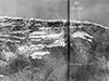 USAAF April 22, 1944  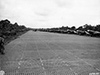 U.S. Army April 1944  U.S. Army April 24, 1944 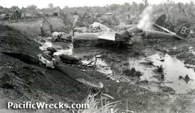 8th PRS April 30, 1944 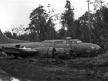 375th TCG May 4, 1944 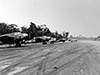 RAAF circa January 1945  Mines April 7, 1973 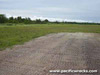 Justin Taylan 2003 |
Location Lat 3° 11' 23S Long 142° 25' 47E Tadji Airfield is located at an elevation of 26' / 8m above sea level about 8 miles west of Tadji in a flat kunai grass covered area inland from the north coast of New Guinea. To the northeast is Korako village and Lemieng village and due north is Pro village and Pro Mission. To the west is Waitanan Creek. Between 1884 until September 1914 part of Deutsch Neu Guinea (German New Guinea). Prewar and during the Pacific War part of the Sepik District in the Territory of New Guinea. The Japanese referred to this location as Aitape Airfield, not to be confused with postwar Aitape Airport. The Allies referred to this location as Tadji Drome or Tadji Dromes (plural) for the two parallel runways. The fighter strip to the north was also known as Korako Airfield for nearby Korako village. Still in use today as Tadji Airport in the Aitape-Lumi District of West Sepik Province (Sandaun Province) in Papua New Guinea (PNG). Construction Prewar, Aitape Airfield (Aitape Aerodrome) was buiilt in a flat kunai grass covered area and used by civil aircraft. In early 1943 occupied by the Japanese Army. The Japanese referred to this location as Aitape Airfield. By the middle of 1943 the Japanese began construction of two parallel runways surfaced with crushed coral. Local laborers from nearby villages were used in the construction. A smaller fighter strip was built to the north closer to the coast. A larger bomber strip with dispersal areas was built at the same locaton as the prewar airfield further inland to the south. By December 1, 1943 the bomber strip measured 6,500' with a flight gap at the western end and a natural clearing with kunai grass at the eastern end with fifteen dispersal areas cut into the forested area to the north and south of the runway. Wartime History Starting in late 1943 used by Japanese Army Air Force (JAAF) fighters and bombers as a satellite field and staging area to dispersal Japanese planes at Hollandia to the west and Wewak area to the east. The Allies referred to this location as Tadji Airfield. Also known as Tadji Dromes (plural) for the two runways. The fighter strip to the north was sometimes referred to as Korako Airfield for nearby Korako village to the northeast. Starting in late August 1943 detected by the Allies and targeted by Allied bombers and fighters and neutralized ahead of the April 22, 1944 American landings at Hollandia and Aitape. Japanese units based at Tadji 248th Hiko Sentai (Ki-43-II) Wewak arrives February 15, 1944–April 1944 disbands American missions against Tadji August 17, 1943–April 21, 1944 On April 22, 1944 Operation Reckless the U.S. Army, 41st Infantry Division (41st ID) "The Jungleers", 163rd Infantry Regiment (163rd IR) made an amphibious landing at Blue Beach. The 1st Battalion advanced to the southwest and captured Tadji Airfield bomber strip from east to west. Immediately engineers from the Royal Australian Air Force (RAAF) 5th Mobile Works Squadron began repairing the north runway (fighter strip). On April 24, 1944 the fighter strip was repaired and operational. The first American planes to land were a pair of P-38 Lightnings piloted by Brigadier General Paul B. Wurtsmith (C.O. 5th Fighter Command) and P-38J "Marge" 42-104380 piloted by Col. Robert L. Morrissey (C.O. 49th FG). The pair of Lightnings were photographed parked at the edge of the runway. That same day, P-40N Kittyhawks from No. 76 Squadron staged from Tadji Airfield for patrols over the Hollandia area. Keith W. Bryant, VX 85794 AIF 7th Mechanical Equipment Co. A.I.F: "At Aitape, and I graded roads and the Tadji Airfield whilst there. I was also on the beach pulling LCT's into the sand so that they could be unloaded. Afterwards, we had to drag them in as the tide came higher, and of course let them out again as the tide receded, I became friendly with some of the native boys in the crews there also." Later, the bomber strip became the main runway and the fighter strip was used only as emergency crash strip. Tadji Airfield was used by both Australian and American planes. Allied units based at Tadji Airfield U.S. Army Air Force (USAAF) 433rd TCG, 65th TCS (C-47 det) Nadzab arrives May 3, 1944–June 2, 1944 departs Nadzab 433rd TCG, 66th TCS (C-47 det) Nadzab arrives May 12, 1944–June 2, 1944 departs Nadzab 433rd TCG, 68th TCS (C-47 det) Nadzab arrives May 18, 1944–June 4, 1944 departs Nadzab 71st TRG, 110th TRS (P-40 Warhawk, P-39 Airacobra) Gusap arrives May 25, 1944–Sept 11, 1944 departs Biak Royal Australian Air Force (RAAF) No. 78 Squadron (P-40N Kittyhawk) Cape Gloucester arrives April 25, 1944–May 1944 departs Hollandia No. 100 Squadron (Beaufort) Nadzab arrives July 1944–March 1946 departs Finschafen 5th Mobile Works Squadron arrives April 22, 1944 12 RSU 1944-1945 Tadji Airfield continued to be used by No. 100 Squadron Beauforts that flew bombing missions against the Japanese until the end of the Pacific War. Between the two runways, No. 12 Repair Salvage Unit (12 RSU) was based to repair and salvage crashed planes and maintained a large bone yard area. On August 15, 1945 Beauforts from No 100 Squadron took off from from Tadji Airfield on their last bombing mission of the Pacific War in New Guinea only an hour before the official surrender of Japan was announced that ended hostilities. At the end of the Pacific War, many Allied planes were abandoned at Tadji Airfield in the bone yard area. Aircraft wreckage abandoned at Tadji Airfield List of Allied aircraft abandoned and salvaged from Tadji Airfield Postwar Since the Pacific War, the northern runway (crash strip) is disused and overgrown. In the early 1970's a six-week recovery operation by Charles Darby and Monty Armstrong funded by American David Tallichet / Yesterday's Air Force (YAF) removed forteen of the most complete aircraft, including six P-40's, frames of Anson, Beauforts, and Tiger Moth UV-Q. Today The southern runway (bomber strip) is still in use today as Tadji Airport. Airport code: IATA: TAD. The runway is one of two in Papua New Guinea (PNG) t surfaced with Marston Mat / Pierced Steel Planking (PSP). References Intelligence Summary, Tadji Airdrome December 1, 1943 via Richard Dunn The Journal of Pacific History "A Bomb Or A Bullet Or The Bloody Flux?: Population Change in the Aitape Inland Papua New Guinea, 1941-1945" by Bryant Allen February 1983 Vol. 18, No. 4 (October 1983) pages 218-235 "The Japanese were building an airstrip there [Tadji Airfield] and appear to have employed mainly people from inland villages nearest to Tadji. When dysentery appeared among those workers the Japanese ordered them home, so it is probable that when a more severe form appeared at Tadji, workers were also ordered to disperse and in doing so carried the disease directly into their home villages from where it spread east and west along the ranges." 248th Hiko Sentai, page 3 by Richard Dunn "After this raid [February 15, 1944] the Japanese fighter units withdrew all their flyable aircraft to rear bases to carry out maintenance and recover their operational strength. 248th [Hiko Sentai] went to Aitape (called Tadji by the Allies)" PNG Attitude "The story how Aitape War Museum lost aircraft worth millions" by Rob Parer June 24, 2016 South Pacific Air War (2024) page 487 Thanks to Charles Darby, Monty Armstrong and Neville Mines for additional information Contribute
Information Last Updated
|
Map March 1944 Map 1944 Map Fallingrain Map Mapcarta Photo Archive |
| Discussion Forum | Daily Updates | Reviews | Museums | Interviews & Oral Histories |
|