|
|
|
|
| Missing In Action (MIA) | Prisoners Of War (POW) | Unexploded Ordnance (UXO) |
| Chronology | Locations | Aircraft | Ships | Submit Info | How You Can Help | Donate |
|
 5th AF May 12, 1942  5th AF c1942 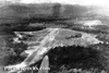 5th AF c1942 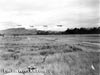 Brown April 13, 1943 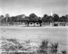  5th AF c1943  Jack Heyn c1943 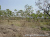 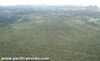 Justin Taylan 2004 |
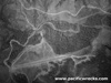
Location 14 Mile Drome was located roughly 14 mile north of Port Moresby inland from the southern coast of New Guinea. Nearby was Twin Peaks (Saddle Mountain). To the south is the Laloki River and to the northeast is Mount Lawes. Also known as Laloki Drome for the nearby Laloki River. On November 10, 1942 named "Schwimmer Drome". Prewar and during World War II located in the Territory of Papua. Today located in the National Capital District (NCD) in Papua New Guinea (PNG). Construction During early 1942, the U.S. Army built a single runway at this location measuring 5,300' x 100'. During October 1942 surfaced with marston matting (PSP) by the 96th Engineers (Negro). No revetments were built at the airfield, but taxiway and parking areas were constructed to the north of the runway in a semicircle. Living quarters were pyramid tents a half mile from the strip among scrub trees. Wartime History 14 Mile Drome was used by the U.S. Army Air Force (USAAF) as a military airfield for fighter aircraft including P-39 Airacobras, P-40 Warhawks and P-38 Lightnings. Also used by photographic reconnaissance F-4 Lightings and F-5 Lightnings from the 6th Photographic Reconnaissance Group (6th PRG), 8th Photographic Reconnaissance Squadron (8th PRS) "Eight Ballers". The runway could accommodate medium bombers including B-25 Mitchells and heavy bombers including B-17 Flying Fortresses. Naming Known as "14 Mile Drome" or "Laloki" after the nearby Laloki River. On November 10, 1942 officially named "Schwimmer Drome" in honor of 2nd Lt. Charles L. Schwimmer pilot P-39D Airacobra 41-6956 Missing In Action (MIA) May 4, 1942 on strafing mission against Lae Airfield at dawn. Japanese missions against 14 Mile Drome (Schwimmer Drome) February 23, 1942–April 12, 1943 American units based at 14 Mile Drome (Schwimmer) 3rd BG, 13th BS (B-25) 49th FG, 7th FS (P-40) Batchelor arrives September 19, 1942 - ? 49th FG, 9th FS (P-40, P-38) Batchelor arrives Oct 10, 1942–Mar 6, 1943 departs Horanda (Dobodura No. 4) 35th FG, 39th FS (P-39, P-38) Garbutt Field October 18, 1942–December 15, 1943 departs Nadzab 6th PRG, 8th PRS (F-4, F-5) Garbutt Field arrives September 9, 1942–departs Dobodura Today Disused since the war, there is little trace of the original strip, settlers have built houses along much of the former runway area. The rest is overgrown and abandoned. Some wartime debris litter the area. Weapons bays are visible from the road for bomb storage prior to loading. Henry Mayer explored the area and adds: "I found a dozen Australian military force buttons and noticed a few horse shoes, mouth bits, harness buckles lying around. This is where i found the Australian yoke & bull whip badge in collection. I then took a walk up the south part of Mount Lawes and noticed two fox holes at different elevations quarter of the way up along with 303 shell casings. I took this shot of Schwimmer Drome area from a outcropping of Mt. Lawes which shows the road on the left flanking the Laloki River (dark green tree belt) and the Laloki mental hospital on the right alongside the main road. The runway would have been where the patches of houses are in the middle while the line along the bottom is a old road which has ordnance bays flanking it on the Lawes side. You can see twin peaks at the right and Jacksons Airport (7 Mile) in the distant background. I also found what seems to be a few human bones stashed under a rock formation at this point, probably an old Koiari burial ground going by the broken pottery along the way." B-26 Marauder 40-1493 Pilot Gammon crashed November 2, 1942 B-25D "Fair Dinkum" 41-29714 Destroyed April 12, 1943 during Japanese air raid. B-25D "Baby Blitz" 41-29705 Damaged April 12, 1943 during Japanese air raid, written off. B-25D "The Grim Reaper" 41-29719 Damaged April 12, 1943 during Japanese air raid. B-17E "R.F.D. Tojo" 41-2627 Pilot Hutchison crashed December 26, 1943 wreckage remained until 1970s. Contribute
Information Last Updated
|
Map July 22, 1943 View in Google Earth Photo Archive |
| Discussion Forum | Daily Updates | Reviews | Museums | Interviews & Oral Histories |
|